Türgen geodata
Türgen (Xinjiang) is a seat of a fourth-order administrative division; located in China in Asia/Urumqi (GMT+6) time zone. In our database, there are 1268 cities with bigger population. Compared to other cities in China, 92.3% of cities are located further ↓South; 98.9% of cities are located further →East and 84.1% of cities have lower elevation than Türgen. Note1


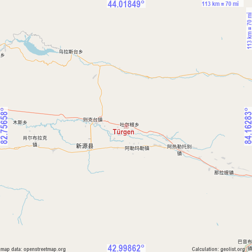
Türgen GPS coordinates[2]
43° 30' 38.556" North, 83° 27' 34.92" East
| Map corner | latitude | longitude |
|---|---|---|
| Upper-left | 44.01849°, | 82.75658° |
| Center: | 43.51071°, | 83.4597° |
| Lower-right: | 42.99862°, | 84.16283° |
| Map W x H: | 113.4×113.4 km | = 70.5×70.5mi |
| max Lat: | 53.31946° ⇑7.7% North |
| Türgen: | 43.51071° |
| min Lat: | ⇓92.3% South 18.22056° |
| min Long | Türgen | max Long |
| 75.07348° | 83.4597° | 134.28917° |
| W 1.1%⇐ | ⇒98.9% E |
Elevation
Elevation of Türgen is 922 m = 3025 ft, and this is 437.2 m = 1434 ft above average elevation for this country.
| Max E: |
5622 m = 18445 ft | 15.9% |
| Türgen | 922 m 3025 ft | |
| Avg. | 484.8 m = 1591 ft | |
Min E: |
-3 m = -10 ft | 84.1% |
See also: China elevation on elevation.city.
Geographical zone
Türgen is located in North temperate zone (between Tropic of Cancer and the Arctic Circle). Distance of this Northern Tropic circle is 2232 km =1386.9 mi to South.| Distance of | km | miles | from Türgen |
|---|---|---|---|
| North Pole | 5169.1 | 3211.9 | to North |
| Arctic Circle | 2563.2 | 1592.7 | to North |
| Tropic Cancer | 2232 | 1386.9 | to South |
| Equator | 4837.9 | 3006.1 | to South |


Nearby cities:
15 places around Türgen: (largest is in red/bold)
• Agarsin
84.9 km =52.8 mi,  268°
268°
• Araltobe
27 km =16.8 mi,  114°
114°
• Baiyanggou
96.6 km =60 mi,  43°
43°
• Ji’ergele Teguoleng
110.2 km =68.5 mi,  31°
31°
• Karasu
108.8 km =67.6 mi,  290°
290°
• Karatobe
71.4 km =44.4 mi, 291°
• Muhur
75.2 km =46.7 mi,  242°
242°
• Nilka
83.5 km =51.9 mi, 291°
• Tabulehete
101.9 km =63.3 mi, 39°
• Taldi
34.5 km =21.4 mi,  251°
251°
• Tikerik
112.7 km =70 mi, 270°
• Tokkuztara
105.9 km =65.8 mi, 267°
• Xinyuan
19.4 km =12.1 mi, 241°
• Xorbulak
40.9 km =25.4 mi,  260°
260°
• Zekti
14.9 km =9.3 mi,  281°
281°
Sources, notices
• [Note1] Compared only with cities in China existing in our database
• [Src1] Map data: © OpenStreetMap contributors (CC-BY-SA)
• [Src2] Other city data from geonames.org with taken over terms of usage.
• [Src3] Geographical zone / Annual Mean Temperature by Robert A. Rohde @ Wikipedia
