Araltobe geodata
Araltobe (Xinjiang) is a seat of a fourth-order administrative division; located in China in Asia/Urumqi (GMT+6) time zone. In our database, there are 1268 cities with bigger population. Compared to other cities in China, 92.2% of cities are located further ↓South; 98.8% of cities are located further →East and 87.2% of cities have lower elevation than Araltobe. Note1


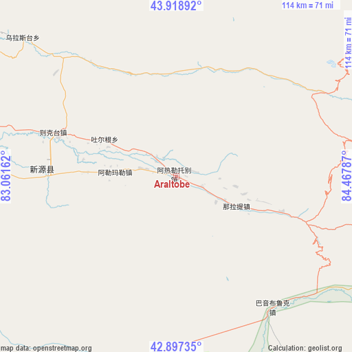
Araltobe GPS coordinates[2]
43° 24' 37.044" North, 83° 45' 53.064" East
| Map corner | latitude | longitude |
|---|---|---|
| Upper-left | 43.91892°, | 83.06162° |
| Center: | 43.41029°, | 83.76474° |
| Lower-right: | 42.89735°, | 84.46787° |
| Map W x H: | 113.6×113.6 km | = 70.6×70.6mi |
| max Lat: | 53.31946° ⇑7.8% North |
| Araltobe: | 43.41029° |
| min Lat: | ⇓92.2% South 18.22056° |
| min Long | Araltobe | max Long |
| 75.07348° | 83.76474° | 134.28917° |
| W 1.2%⇐ | ⇒98.8% E |
Elevation
Elevation of Araltobe is 1123 m = 3684 ft, and this is 638.2 m = 2094 ft above average elevation for this country.
| Max E: |
5622 m = 18445 ft | 12.8% |
| Araltobe | 1123 m 3684 ft | |
| Avg. | 484.8 m = 1591 ft | |
Min E: |
-3 m = -10 ft | 87.2% |
See also: China elevation on elevation.city.
Geographical zone
Araltobe is located in North temperate zone (between Tropic of Cancer and the Arctic Circle). Distance of this Northern Tropic circle is 2220.9 km =1380 mi to South.| Distance of | km | miles | from Araltobe |
|---|---|---|---|
| North Pole | 5180.3 | 3218.9 | to North |
| Arctic Circle | 2574.4 | 1599.7 | to North |
| Tropic Cancer | 2220.9 | 1380 | to South |
| Equator | 4826.8 | 2999.2 | to South |


Nearby cities:
15 places around Araltobe: (largest is in red/bold)
• Agarsin
109.9 km =68.3 mi,  274°
274°
• Baiquan
121.2 km =75.3 mi,  22°
22°
• Baiyanggou
91.3 km =56.7 mi,  27°
27°
• Hatu Buh
119.5 km =74.3 mi, 21°
• Ji’ergele Teguoleng
110.2 km =68.5 mi, 17°
• Karatobe
98.5 km =61.2 mi,  292°
292°
• Muhur
94.5 km =58.7 mi,  255°
255°
• Nilka
110.5 km =68.7 mi, 292°
• Sikeshu
113.3 km =70.4 mi, 19°
• Tabulehete
98.5 km =61.2 mi, 24°
• Taldi
57.4 km =35.7 mi, 270°
• Türgen
27 km =16.8 mi, 294°
• Xinyuan
41.6 km =25.8 mi, 272°
• Xorbulak
65.2 km =40.5 mi, 273°
• Zekti
41.7 km =25.9 mi, 289°
Sources, notices
• [Note1] Compared only with cities in China existing in our database
• [Src1] Map data: © OpenStreetMap contributors (CC-BY-SA)
• [Src2] Other city data from geonames.org with taken over terms of usage.
• [Src3] Geographical zone / Annual Mean Temperature by Robert A. Rohde @ Wikipedia
