Qiaze geodata
Qiaze (Tibet) is a seat of a fourth-order administrative division; located in China in Asia/Shanghai (GMT+8) time zone. In our database, there are 1268 cities with bigger population. Compared to other cities in China, 59.5% of cities are located further ↓South; 96.6% of cities are located further →East and 99.7% of cities have lower elevation than Qiaze. Note1


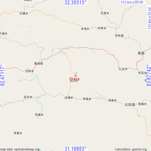
Qiaze GPS coordinates[2]
31° 42' 32.112" North, 93° 10' 27.444" East
| Map corner | latitude | longitude |
|---|---|---|
| Upper-left | 32.30515°, | 92.47117° |
| Center: | 31.70892°, | 93.17429° |
| Lower-right: | 31.10883°, | 93.87742° |
| Map W x H: | 133×133 km | = 82.6×82.6mi |
| max Lat: | 53.31946° ⇑40.5% North |
| Qiaze: | 31.70892° |
| min Lat: | ⇓59.5% South 18.22056° |
| min Long | Qiaze | max Long |
| 75.07348° | 93.17429° | 134.28917° |
| W 3.4%⇐ | ⇒96.6% E |
Elevation
Elevation of Qiaze is 4590 m = 15059 ft, and this is 4105.2 m = 13469 ft above average elevation for this country.
| Max E: |
5622 m = 18445 ft | 0.3% |
| Qiaze | 4590 m 15059 ft | |
| Avg. | 484.8 m = 1591 ft | |
Min E: |
-3 m = -10 ft | 99.7% |
See also: China elevation on elevation.city.
Geographical zone
Qiaze is located in North temperate zone (between Tropic of Cancer and the Arctic Circle). Distance of this Northern Tropic circle is 919.8 km =571.5 mi to South.| Distance of | km | miles | from Qiaze |
|---|---|---|---|
| North Pole | 6481.4 | 4027.4 | to North |
| Arctic Circle | 3875.5 | 2408.1 | to North |
| Tropic Cancer | 919.8 | 571.5 | to South |
| Equator | 3525.7 | 2190.8 | to South |


Nearby cities:
15 places around Qiaze: (largest is in red/bold)
• Biru
53.9 km =33.5 mi,  117°
117°
• Biruxong
53 km =32.9 mi,  130°
130°
• Caqu
22.8 km =14.2 mi,  153°
153°
• Daqian
40.2 km =25 mi,  276°
276°
• Kormang
70.8 km =44 mi,  269°
269°
• Lainqu
38.4 km =23.9 mi, 122°
• Nyima
45.7 km =28.4 mi,  246°
246°
• Rawa
61 km =37.9 mi,  88°
88°
• Rogda
65 km =40.4 mi, 92°
• Sexiong
47 km =29.2 mi,  223°
223°
• Xagqu
34.7 km =21.6 mi,  288°
288°
• Xamqu
63.3 km =39.3 mi,  113°
113°
• Yag La
60.5 km =37.6 mi,  70°
70°
• Zaindainxoi
49.1 km =30.5 mi, 71°
• Zala
41.6 km =25.8 mi,  81°
81°
Sources, notices
• [Note1] Compared only with cities in China existing in our database
• [Src1] Map data: © OpenStreetMap contributors (CC-BY-SA)
• [Src2] Other city data from geonames.org with taken over terms of usage.
• [Src3] Geographical zone / Annual Mean Temperature by Robert A. Rohde @ Wikipedia
