Caqu geodata
Caqu (Tibet) is a seat of a fourth-order administrative division; located in China in Asia/Shanghai (GMT+8) time zone. In our database, there are 1268 cities with bigger population. Compared to other cities in China, 58.6% of cities are located further ↓South; 96.6% of cities are located further →East and 98.7% of cities have lower elevation than Caqu. Note1


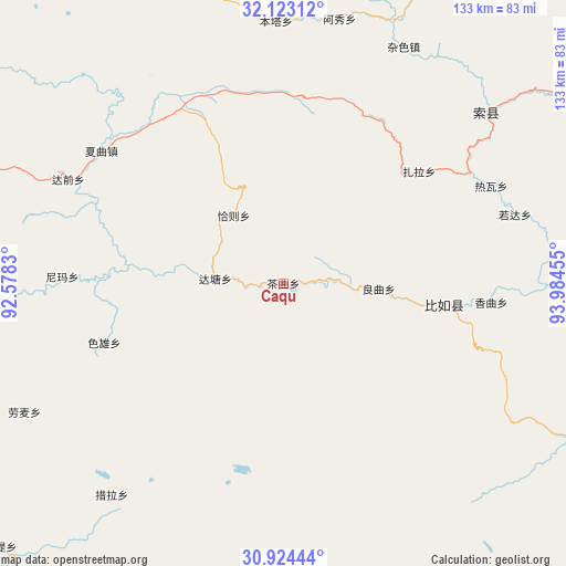
Caqu GPS coordinates[2]
31° 31' 32.52" North, 93° 16' 53.112" East
| Map corner | latitude | longitude |
|---|---|---|
| Upper-left | 32.12312°, | 92.5783° |
| Center: | 31.5257°, | 93.28142° |
| Lower-right: | 30.92444°, | 93.98455° |
| Map W x H: | 133.3×133.3 km | = 82.8×82.8mi |
| max Lat: | 53.31946° ⇑41.4% North |
| Caqu: | 31.5257° |
| min Lat: | ⇓58.6% South 18.22056° |
| min Long | Caqu | max Long |
| 75.07348° | 93.28142° | 134.28917° |
| W 3.4%⇐ | ⇒96.6% E |
Elevation
Elevation of Caqu is 4063 m = 13330 ft, and this is 3578.2 m = 11740 ft above average elevation for this country.
| Max E: |
5622 m = 18445 ft | 1.3% |
| Caqu | 4063 m 13330 ft | |
| Avg. | 484.8 m = 1591 ft | |
Min E: |
-3 m = -10 ft | 98.7% |
See also: China elevation on elevation.city.
Geographical zone
Caqu is located in North temperate zone (between Tropic of Cancer and the Arctic Circle). Distance of this Northern Tropic circle is 899.4 km =558.9 mi to South.| Distance of | km | miles | from Caqu |
|---|---|---|---|
| North Pole | 6501.7 | 4040 | to North |
| Arctic Circle | 3895.8 | 2420.7 | to North |
| Tropic Cancer | 899.4 | 558.9 | to South |
| Equator | 3505.3 | 2178.1 | to South |


Nearby cities:
15 places around Caqu: (largest is in red/bold)
• Biru
37.8 km =23.5 mi,  97°
97°
• Biruxong
33.3 km =20.7 mi,  114°
114°
• Cola
63.7 km =39.6 mi,  218°
218°
• Daqian
55.8 km =34.7 mi,  296°
296°
• Lainqu
22.2 km =13.8 mi,  90°
90°
• Nyima
52.1 km =32.4 mi,  272°
272°
• Qiaze
22.8 km =14.2 mi,  333°
333°
• Rawa
55.3 km =34.4 mi,  66°
66°
• Rogda
57.5 km =35.7 mi, 72°
• Sexiong
44.6 km =27.7 mi,  251°
251°
• Xagqu
53.3 km =33.1 mi,  306°
306°
• Xamqu
48.3 km =30 mi, 95°
• Yag La
62.2 km =38.6 mi,  48°
48°
• Zaindainxoi
51.3 km =31.9 mi, 45°
• Zala
40.9 km =25.4 mi, 49°
Sources, notices
• [Note1] Compared only with cities in China existing in our database
• [Src1] Map data: © OpenStreetMap contributors (CC-BY-SA)
• [Src2] Other city data from geonames.org with taken over terms of usage.
• [Src3] Geographical zone / Annual Mean Temperature by Robert A. Rohde @ Wikipedia
