Xagqu geodata
Xagqu (Tibet) is a seat of a fourth-order administrative division; located in China in Asia/Shanghai (GMT+8) time zone. In our database, there are 1268 cities with bigger population. Compared to other cities in China, 60.2% of cities are located further ↓South; 96.7% of cities are located further →East and 99.1% of cities have lower elevation than Xagqu. Note1


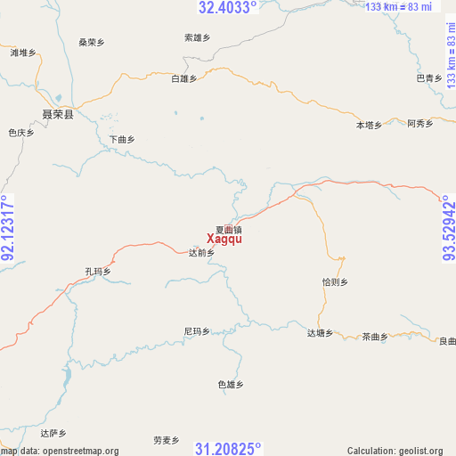
Xagqu GPS coordinates[2]
31° 48' 27.756" North, 92° 49' 34.644" East
| Map corner | latitude | longitude |
|---|---|---|
| Upper-left | 32.4033°, | 92.12317° |
| Center: | 31.80771°, | 92.82629° |
| Lower-right: | 31.20825°, | 93.52942° |
| Map W x H: | 132.9×132.9 km | = 82.6×82.6mi |
| max Lat: | 53.31946° ⇑39.8% North |
| Xagqu: | 31.80771° |
| min Lat: | ⇓60.2% South 18.22056° |
| min Long | Xagqu | max Long |
| 75.07348° | 92.82629° | 134.28917° |
| W 3.3%⇐ | ⇒96.7% E |
Elevation
Elevation of Xagqu is 4254 m = 13957 ft, and this is 3769.2 m = 12366 ft above average elevation for this country.
| Max E: |
5622 m = 18445 ft | 0.90000000000001% |
| Xagqu | 4254 m 13957 ft | |
| Avg. | 484.8 m = 1591 ft | |
Min E: |
-3 m = -10 ft | 99.1% |
See also: China elevation on elevation.city.
Geographical zone
Xagqu is located in North temperate zone (between Tropic of Cancer and the Arctic Circle). Distance of this Northern Tropic circle is 930.8 km =578.4 mi to South.| Distance of | km | miles | from Xagqu |
|---|---|---|---|
| North Pole | 6470.4 | 4020.5 | to North |
| Arctic Circle | 3864.5 | 2401.3 | to North |
| Tropic Cancer | 930.8 | 578.4 | to South |
| Equator | 3536.7 | 2197.6 | to South |


Nearby cities:
15 places around Xagqu: (largest is in red/bold)
• Caqu
53.3 km =33.1 mi,  126°
126°
• Cola
80.9 km =50.3 mi,  177°
177°
• Dagsar
78.3 km =48.7 mi,  220°
220°
• Daqian
9.8 km =6.1 mi,  226°
226°
• Kormang
39.8 km =24.7 mi,  252°
252°
• Lainqu
72.5 km =45 mi,  115°
115°
• Lomai
64.1 km =39.8 mi,  196°
196°
• Nierong
60.5 km =37.6 mi,  304°
304°
• Nyima
30.7 km =19.1 mi, 196°
• Nyima
54.4 km =33.8 mi,  264°
264°
• Qiaze
34.7 km =21.6 mi,  108°
108°
• Segong
80.9 km =50.3 mi, 304°
• Sexiong
45.3 km =28.1 mi, 179°
• Zaindainxoi
79.5 km =49.4 mi,  86°
86°
• Zala
74.2 km =46.1 mi, 93°
Sources, notices
• [Note1] Compared only with cities in China existing in our database
• [Src1] Map data: © OpenStreetMap contributors (CC-BY-SA)
• [Src2] Other city data from geonames.org with taken over terms of usage.
• [Src3] Geographical zone / Annual Mean Temperature by Robert A. Rohde @ Wikipedia
