Xiaoguai geodata
Xiaoguai (Xinjiang) is a seat of a fourth-order administrative division; located in China in Asia/Urumqi (GMT+6) time zone. In our database, there are 1268 cities with bigger population. Compared to other cities in China, 94% of cities are located further ↓South; 98.6% of cities are located further →East and 62.6% of cities have lower elevation than Xiaoguai. Note1


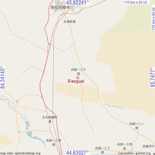
Xiaoguai GPS coordinates[2]
45° 7' 42.6" North, 85° 2' 40.452" East
| Map corner | latitude | longitude |
|---|---|---|
| Upper-left | 45.62241°, | 84.34145° |
| Center: | 45.1285°, | 85.04457° |
| Lower-right: | 44.63027°, | 85.7477° |
| Map W x H: | 110.3×110.3 km | = 68.5×68.5mi |
| max Lat: | 53.31946° ⇑6% North |
| Xiaoguai: | 45.1285° |
| min Lat: | ⇓94% South 18.22056° |
| min Long | Xiaoguai | max Long |
| 75.07348° | 85.04457° | 134.28917° |
| W 1.4%⇐ | ⇒98.6% E |
Elevation
Elevation of Xiaoguai is 291 m = 955 ft, and this is 193.8 m = 636 ft below average elevation for this country.
| Max E: |
5622 m = 18445 ft | 37.4% |
| Avg. | 484.8 m = 1591 ft | |
| Xiaoguai | 291 m = 955 ft | |
Min E: |
-3 m = -10 ft | 62.6% |
See also: China elevation on elevation.city.
Geographical zone
Xiaoguai is located in North temperate zone (between Tropic of Cancer and the Arctic Circle). Distance of this North polar circle is 2383.4 km =1481 mi to North.| Distance of | km | miles | from Xiaoguai |
|---|---|---|---|
| North Pole | 4989.2 | 3100.1 | to North |
| Arctic Circle | 2383.4 | 1481 | to North |
| Tropic Cancer | 2411.9 | 1498.7 | to South |
| Equator | 5017.8 | 3117.9 | to South |


Nearby cities:
15 places around Xiaoguai: (largest is in red/bold)
• Baijiantan
63.2 km =39.3 mi,  6°
6°
• Dongpaizi
50.9 km =31.6 mi,  241°
241°
• Huanggong
64.4 km =40 mi,  199°
199°
• Jiahezi
74.5 km =46.3 mi, 195°
• Jinlong
50 km =31.1 mi,  355°
355°
• Jiujianlou
67.4 km =41.9 mi,  194°
194°
• Kaiganqi
79.4 km =49.3 mi,  171°
171°
• Karamay
52.2 km =32.4 mi,  346°
346°
• Kuytun
78.8 km =49 mi, 188°
• Laoshawan
79.5 km =49.4 mi,  133°
133°
• Sanping
54.5 km =33.9 mi,  1°
1°
• Shiqiao
60.7 km =37.7 mi,  256°
256°
• Sidaohezi
71.3 km =44.3 mi, 133°
• Toutai
55.2 km =34.3 mi,  215°
215°
• Xihu
73.9 km =45.9 mi,  206°
206°
Sources, notices
• [Note1] Compared only with cities in China existing in our database
• [Src1] Map data: © OpenStreetMap contributors (CC-BY-SA)
• [Src2] Other city data from geonames.org with taken over terms of usage.
• [Src3] Geographical zone / Annual Mean Temperature by Robert A. Rohde @ Wikipedia
