Karamay geodata
Karamay (Xinjiang) is a populated place; located in China in Asia/Urumqi (GMT+6) time zone. With population of 260,000 people, there are 192 cities with bigger population in this country. Compared to other cities in China, 94.5% of cities are located further ↓South; 98.6% of cities are located further →East and 67.4% of cities have lower elevation than Karamay. Note1


Karamay GPS coordinates[2]
45° 35' 5.028" North, 84° 53' 14.064" East
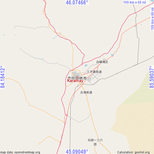
| Map corner | latitude | longitude |
|---|---|---|
| Upper-left | 46.07466°, | 84.18412° |
| Center: | 45.58473°, | 84.88724° |
| Lower-right: | 45.09049°, | 85.59037° |
| Map W x H: | 109.4×109.4 km | = 68×68mi |
| max Lat: | 53.31946° ⇑5.5% North |
| Karamay: | 45.58473° |
| min Lat: | ⇓94.5% South 18.22056° |
| min Long | Karamay | max Long |
| 75.07348° | 84.88724° | 134.28917° |
| W 1.4%⇐ | ⇒98.6% E |
Elevation
Elevation of Karamay is 366 m = 1201 ft, and this is 118.8 m = 390 ft below average elevation for this country.
| Max E: |
5622 m = 18445 ft | 32.6% |
| Avg. | 484.8 m = 1591 ft | |
| Karamay | 366 m = 1201 ft | |
Min E: |
-3 m = -10 ft | 67.4% |
See also: Karamay elevation on elevation.city.
Geographical zone
Karamay is located in North temperate zone (between Tropic of Cancer and the Arctic Circle). Distance of this North polar circle is 2332.6 km =1449.4 mi to North.| Distance of | km | miles | from Karamay |
|---|---|---|---|
| North Pole | 4938.5 | 3068.6 | to North |
| Arctic Circle | 2332.6 | 1449.4 | to North |
| Tropic Cancer | 2462.6 | 1530.2 | to South |
| Equator | 5068.5 | 3149.4 | to South |


Nearby cities:
15 places around Karamay: (largest is in red/bold)
• Baijiantan
23 km =14.3 mi,  58°
58°
• Baikouquan
58.7 km =36.5 mi,  50°
50°
• Dolati
106.5 km =66.2 mi,  296°
296°
• Dongpaizi
81.5 km =50.6 mi,  203°
203°
• Jinlong
8.2 km =5.1 mi,  95°
95°
• Lamazhao
85.7 km =53.3 mi,  330°
330°
• Miao’ergou
80.1 km =49.8 mi,  264°
264°
• Sanping
13.7 km =8.5 mi,  73°
73°
• Shiqiao
79.7 km =49.5 mi,  215°
215°
• Tiechanggou
73.8 km =45.9 mi, 331°
• Toli
107.3 km =66.7 mi,  291°
291°
• Toutai
97.5 km =60.6 mi,  191°
191°
• Urho
85.1 km =52.9 mi, 45°
• Wuxuete
91.2 km =56.7 mi,  308°
308°
• Xiaoguai
52.2 km =32.4 mi,  166°
166°
Sources, notices
• [Note1] Compared only with cities in China existing in our database
• [Src1] Map data: © OpenStreetMap contributors (CC-BY-SA)
• [Src2] Other city data from geonames.org with taken over terms of usage.
• [Src3] Geographical zone / Annual Mean Temperature by Robert A. Rohde @ Wikipedia
