Tashi geodata
Tashi (Gansu) is a seat of a fourth-order administrative division; located in China in Asia/Urumqi (GMT+6) time zone. In our database, there are 1268 cities with bigger population. Compared to other cities in China, 87.4% of cities are located further ↓South; 95.9% of cities are located further →East and 89.6% of cities have lower elevation than Tashi. Note1


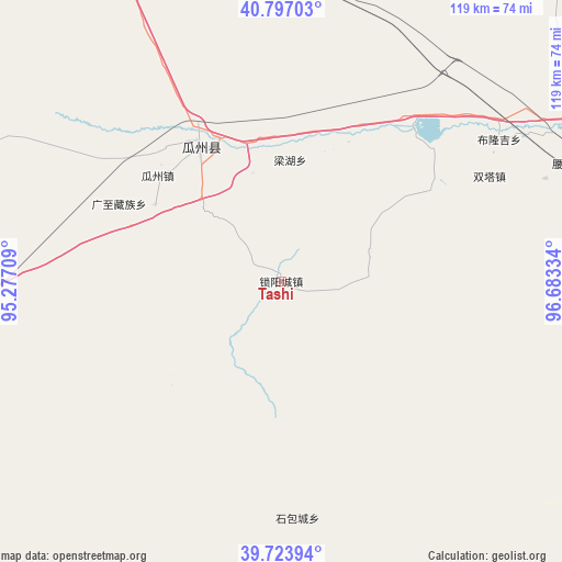
Tashi GPS coordinates[2]
40° 15' 45.396" North, 95° 58' 48.756" East
| Map corner | latitude | longitude |
|---|---|---|
| Upper-left | 40.79703°, | 95.27709° |
| Center: | 40.26261°, | 95.98021° |
| Lower-right: | 39.72394°, | 96.68334° |
| Map W x H: | 119.3×119.3 km | = 74.1×74.1mi |
| max Lat: | 53.31946° ⇑12.6% North |
| Tashi: | 40.26261° |
| min Lat: | ⇓87.4% South 18.22056° |
| min Long | Tashi | max Long |
| 75.07348° | 95.98021° | 134.28917° |
| W 4.1%⇐ | ⇒95.9% E |
Elevation
Elevation of Tashi is 1319 m = 4327 ft, and this is 834.2 m = 2737 ft above average elevation for this country.
| Max E: |
5622 m = 18445 ft | 10.4% |
| Tashi | 1319 m 4327 ft | |
| Avg. | 484.8 m = 1591 ft | |
Min E: |
-3 m = -10 ft | 89.6% |
See also: China elevation on elevation.city.
Geographical zone
Tashi is located in North temperate zone (between Tropic of Cancer and the Arctic Circle). Distance of this Northern Tropic circle is 1870.9 km =1162.5 mi to South.| Distance of | km | miles | from Tashi |
|---|---|---|---|
| North Pole | 5530.3 | 3436.4 | to North |
| Arctic Circle | 2924.4 | 1817.1 | to North |
| Tropic Cancer | 1870.9 | 1162.5 | to South |
| Equator | 4476.8 | 2781.8 | to South |


Nearby cities:
15 places around Tashi: (largest is in red/bold)
• Bulongji
56.1 km =34.9 mi,  57°
57°
• Changma
80.1 km =49.8 mi,  123°
123°
• Dongbatu
32.2 km =20 mi,  226°
226°
• Guazhou
34.4 km =21.4 mi,  310°
310°
• Hedong
72.2 km =44.9 mi,  68°
68°
• Huancheng
34.6 km =21.5 mi,  328°
328°
• Huangzhawan
92.7 km =57.6 mi,  81°
81°
• Liuhe
82.7 km =51.4 mi, 78°
• Nancha
31.5 km =19.6 mi,  301°
301°
• Qiaozi
20 km =12.4 mi, 70°
• Sandaogou
77.4 km =48.1 mi, 75°
• Shibaocheng
52 km =32.3 mi,  171°
171°
• Xihu
89.2 km =55.4 mi,  290°
290°
• Yaozhanzi
67.1 km =41.7 mi, 69°
• Yuanquan
30.5 km =19 mi, 329°
Sources, notices
• [Note1] Compared only with cities in China existing in our database
• [Src1] Map data: © OpenStreetMap contributors (CC-BY-SA)
• [Src2] Other city data from geonames.org with taken over terms of usage.
• [Src3] Geographical zone / Annual Mean Temperature by Robert A. Rohde @ Wikipedia
