Luntai geodata
Luntai (Xinjiang) is a seat of a third-order administrative division; located in China in Asia/Urumqi (GMT+6) time zone. In our database, there are 1268 cities with bigger population. Compared to other cities in China, 90.6% of cities are located further ↓South; 98.7% of cities are located further →East and 84.8% of cities have lower elevation than Luntai. Note1


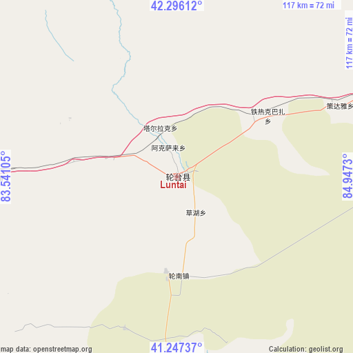
Luntai GPS coordinates[2]
41° 46' 26.004" North, 84° 14' 39.012" East
| Map corner | latitude | longitude |
|---|---|---|
| Upper-left | 42.29612°, | 83.54105° |
| Center: | 41.77389°, | 84.24417° |
| Lower-right: | 41.24737°, | 84.9473° |
| Map W x H: | 116.6×116.6 km | = 72.5×72.5mi |
| max Lat: | 53.31946° ⇑9.4% North |
| Luntai: | 41.77389° |
| min Lat: | ⇓90.6% South 18.22056° |
| min Long | Luntai | max Long |
| 75.07348° | 84.24417° | 134.28917° |
| W 1.3%⇐ | ⇒98.7% E |
Elevation
Elevation of Luntai is 972 m = 3189 ft, and this is 487.2 m = 1598 ft above average elevation for this country.
| Max E: |
5622 m = 18445 ft | 15.2% |
| Luntai | 972 m 3189 ft | |
| Avg. | 484.8 m = 1591 ft | |
Min E: |
-3 m = -10 ft | 84.8% |
See also: China elevation on elevation.city.
Geographical zone
Luntai is located in North temperate zone (between Tropic of Cancer and the Arctic Circle). Distance of this Northern Tropic circle is 2038.9 km =1266.9 mi to South.| Distance of | km | miles | from Luntai |
|---|---|---|---|
| North Pole | 5362.2 | 3331.9 | to North |
| Arctic Circle | 2756.4 | 1712.7 | to North |
| Tropic Cancer | 2038.9 | 1266.9 | to South |
| Equator | 4644.8 | 2886.1 | to South |


Nearby cities:
15 places around Luntai: (largest is in red/bold)
• Alakaga
125.3 km =77.9 mi,  258°
258°
• Hongqi
120.8 km =75.1 mi,  252°
252°
• Keyi
139.8 km =86.9 mi,  287°
287°
• Kizil
150.1 km =93.3 mi,  271°
271°
• Korla
158.2 km =98.3 mi,  90°
90°
• Kuqa
109.2 km =67.9 mi, 266°
• Payxambabazar
143.2 km =89 mi, 255°
• Qiman
113.8 km =70.7 mi, 256°
• Sairam
173.9 km =108.1 mi, 269°
• Tamutuo Gelake
158.5 km =98.5 mi, 252°
• Xayar
134.2 km =83.4 mi,  243°
243°
• Xinhe
137.5 km =85.4 mi, 259°
• Yengimahalla
140.8 km =87.5 mi, 250°
• Youludu Sibage
155.8 km =96.8 mi, 260°
• Yuli
174.4 km =108.4 mi,  106°
106°
Sources, notices
• [Note1] Compared only with cities in China existing in our database
• [Src1] Map data: © OpenStreetMap contributors (CC-BY-SA)
• [Src2] Other city data from geonames.org with taken over terms of usage.
• [Src3] Geographical zone / Annual Mean Temperature by Robert A. Rohde @ Wikipedia
