Korla geodata
Korla (Xinjiang) is a seat of a third-order administrative division; located in China in Asia/Urumqi (GMT+6) time zone. With population of 179,465 people, there are 250 cities with bigger population in this country. Compared to other cities in China, 90.6% of cities are located further ↓South; 98.3% of cities are located further →East and 84.4% of cities have lower elevation than Korla. Note1


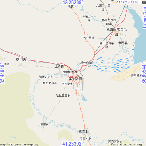
Korla GPS coordinates[2]
41° 45' 37.98" North, 86° 9' 8.316" East
| Map corner | latitude | longitude |
|---|---|---|
| Upper-left | 42.28289°, | 85.44919° |
| Center: | 41.76055°, | 86.15231° |
| Lower-right: | 41.23392°, | 86.85544° |
| Map W x H: | 116.6×116.6 km | = 72.5×72.5mi |
| max Lat: | 53.31946° ⇑9.4% North |
| Korla: | 41.76055° |
| min Lat: | ⇓90.6% South 18.22056° |
| min Long | Korla | max Long |
| 75.07348° | 86.15231° | 134.28917° |
| W 1.7%⇐ | ⇒98.3% E |
Elevation
Elevation of Korla is 945 m = 3100 ft, and this is 460.2 m = 1510 ft above average elevation for this country.
| Max E: |
5622 m = 18445 ft | 15.6% |
| Korla | 945 m 3100 ft | |
| Avg. | 484.8 m = 1591 ft | |
Min E: |
-3 m = -10 ft | 84.4% |
See also: Korla elevation on elevation.city.
Geographical zone
Korla is located in North temperate zone (between Tropic of Cancer and the Arctic Circle). Distance of this Northern Tropic circle is 2037.4 km =1266 mi to South.| Distance of | km | miles | from Korla |
|---|---|---|---|
| North Pole | 5363.7 | 3332.8 | to North |
| Arctic Circle | 2757.8 | 1713.6 | to North |
| Tropic Cancer | 2037.4 | 1266 | to South |
| Equator | 4643.3 | 2885.2 | to South |


Nearby cities:
15 places around Korla: (largest is in red/bold)
• Baluntaicun
101.9 km =63.3 mi,  7°
7°
• Bohu
46.2 km =28.7 mi,  57°
57°
• Dabancheng
251.1 km =156 mi,  44°
44°
• Ewirgol
182.4 km =113.3 mi, 42°
• Hejing
64.7 km =40.2 mi,  17°
17°
• Hoxut
80.4 km =50 mi,  46°
46°
• Huoche Xizhan
256.5 km =159.4 mi, 23°
• Luntai
158.2 km =98.3 mi,  270°
270°
• Sishilichengzi
35 km =21.7 mi, 50°
• Toksun
234.8 km =145.9 mi, 60°
• Xingfulu
255.4 km =158.7 mi,  28°
28°
• Yangzi Jianglu
252.6 km =157 mi, 27°
• Yanqi
47.9 km =29.8 mi, 45°
• Yuli
47.9 km =29.8 mi,  169°
169°
• Ürümqi
255.8 km =158.9 mi, 27°
Sources, notices
• [Note1] Compared only with cities in China existing in our database
• [Src1] Map data: © OpenStreetMap contributors (CC-BY-SA)
• [Src2] Other city data from geonames.org with taken over terms of usage.
• [Src3] Geographical zone / Annual Mean Temperature by Robert A. Rohde @ Wikipedia
