Yuli geodata
Yuli (Xinjiang) is a seat of a third-order administrative division; located in China in Asia/Urumqi (GMT+6) time zone. In our database, there are 1268 cities with bigger population. Compared to other cities in China, 89.8% of cities are located further ↓South; 98.3% of cities are located further →East and 83.6% of cities have lower elevation than Yuli. Note1


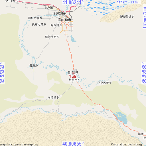
Yuli GPS coordinates[2]
41° 20' 11.832" North, 86° 15' 24.3" East
| Map corner | latitude | longitude |
|---|---|---|
| Upper-left | 41.86241°, | 85.55363° |
| Center: | 41.33662°, | 86.25675° |
| Lower-right: | 40.80655°, | 86.95988° |
| Map W x H: | 117.4×117.4 km | = 72.9×72.9mi |
| max Lat: | 53.31946° ⇑10.2% North |
| Yuli: | 41.33662° |
| min Lat: | ⇓89.8% South 18.22056° |
| min Long | Yuli | max Long |
| 75.07348° | 86.25675° | 134.28917° |
| W 1.7%⇐ | ⇒98.3% E |
Elevation
Elevation of Yuli is 890 m = 2920 ft, and this is 405.2 m = 1329 ft above average elevation for this country.
| Max E: |
5622 m = 18445 ft | 16.4% |
| Yuli | 890 m 2920 ft | |
| Avg. | 484.8 m = 1591 ft | |
Min E: |
-3 m = -10 ft | 83.6% |
See also: China elevation on elevation.city.
Geographical zone
Yuli is located in North temperate zone (between Tropic of Cancer and the Arctic Circle). Distance of this Northern Tropic circle is 1990.3 km =1236.7 mi to South.| Distance of | km | miles | from Yuli |
|---|---|---|---|
| North Pole | 5410.9 | 3362.2 | to North |
| Arctic Circle | 2805 | 1742.9 | to North |
| Tropic Cancer | 1990.3 | 1236.7 | to South |
| Equator | 4596.2 | 2855.9 | to South |


Nearby cities:
15 places around Yuli: (largest is in red/bold)
• Baluntaicun
148.2 km =92.1 mi,  2°
2°
• Bohu
78.1 km =48.5 mi,  22°
22°
• Dabancheng
281.5 km =174.9 mi,  37°
37°
• Ewirgol
214.8 km =133.5 mi,  32°
32°
• Hejing
109.4 km =68 mi,  5°
5°
• Hongqi
283.5 km =176.2 mi,  272°
272°
• Hoxut
114 km =70.8 mi, 25°
• Korla
47.9 km =29.8 mi,  349°
349°
• Kuqa
280.1 km =174 mi,  278°
278°
• Luntai
174.4 km =108.4 mi,  286°
286°
• Qiman
279.7 km =173.8 mi, 274°
• Sishilichengzi
71.9 km =44.7 mi, 14°
• Toksun
254.9 km =158.4 mi,  50°
50°
• Xayar
288.6 km =179.3 mi, 267°
• Yanqi
84.7 km =52.6 mi, 17°
Sources, notices
• [Note1] Compared only with cities in China existing in our database
• [Src1] Map data: © OpenStreetMap contributors (CC-BY-SA)
• [Src2] Other city data from geonames.org with taken over terms of usage.
• [Src3] Geographical zone / Annual Mean Temperature by Robert A. Rohde @ Wikipedia
