Hecheng geodata
Hecheng (Anhui) is a seat of a fourth-order administrative division; located in China in Asia/Shanghai (GMT+8) time zone. In our database, there are 1268 cities with bigger population. Compared to other cities in China, 57.9% of cities are located further ↑North; 69.5% of cities are located further ←West and 66.2% of cities have lower elevation than Hecheng. Note1


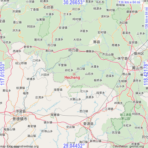
Hecheng GPS coordinates[2]
29° 39' 26.568" North, 117° 43' 7.14" East
| Map corner | latitude | longitude |
|---|---|---|
| Upper-left | 30.26653°, | 117.01553° |
| Center: | 29.65738°, | 117.71865° |
| Lower-right: | 29.04452°, | 118.42178° |
| Map W x H: | 135.9×135.9 km | = 84.4×84.4mi |
| max Lat: | 53.31946° ⇑57.9% North |
| Hecheng: | 29.65738° |
| min Lat: | ⇓42.1% South 18.22056° |
| min Long | Hecheng | max Long |
| 75.07348° | 117.71865° | 134.28917° |
| W 69.5%⇐ | ⇒30.5% E |
Elevation
Elevation of Hecheng is 347 m = 1138 ft, and this is 137.8 m = 452 ft below average elevation for this country.
| Max E: |
5622 m = 18445 ft | 33.8% |
| Avg. | 484.8 m = 1591 ft | |
| Hecheng | 347 m = 1138 ft | |
Min E: |
-3 m = -10 ft | 66.2% |
See also: China elevation on elevation.city.
Geographical zone
Hecheng is located in North temperate zone (between Tropic of Cancer and the Arctic Circle). Distance of this Northern Tropic circle is 691.7 km =429.8 mi to South.| Distance of | km | miles | from Hecheng |
|---|---|---|---|
| North Pole | 6709.5 | 4169.1 | to North |
| Arctic Circle | 4103.6 | 2549.9 | to North |
| Tropic Cancer | 691.7 | 429.8 | to South |
| Equator | 3297.6 | 2049 | to South |


Nearby cities:
15 places around Hecheng: (largest is in red/bold)
• Bingtan
20.4 km =12.7 mi,  69°
69°
• Jinzipai
22.7 km =14.1 mi,  22°
22°
• Liukou
8.1 km =5 mi,  49°
49°
• Luxi
21.2 km =13.2 mi,  285°
285°
• Pingli
13.8 km =8.6 mi,  309°
309°
• Qiaoshan
11.9 km =7.4 mi,  0°
0°
• Qihong
6.4 km =4 mi, 311°
• Qishan
20.8 km =12.9 mi, 0°
• Rongkou
19.8 km =12.3 mi,  299°
299°
• Shanhou
14.1 km =8.8 mi,  88°
88°
• Tafang
14.7 km =9.1 mi,  339°
339°
• Tuochuan
18 km =11.2 mi,  148°
148°
• Wangcun
8.9 km =5.5 mi,  110°
110°
• Yaoli
18.6 km =11.6 mi,  228°
228°
• Zhangshan
22.7 km =14.1 mi,  177°
177°
Sources, notices
• [Note1] Compared only with cities in China existing in our database
• [Src1] Map data: © OpenStreetMap contributors (CC-BY-SA)
• [Src2] Other city data from geonames.org with taken over terms of usage.
• [Src3] Geographical zone / Annual Mean Temperature by Robert A. Rohde @ Wikipedia
