Huayang geodata
Huayang (Anhui) is a seat of a third-order administrative division; located in China in Asia/Shanghai (GMT+8) time zone. In our database, there are 1268 cities with bigger population. Compared to other cities in China, 53.3% of cities are located further ↑North; 73.8% of cities are located further ←West and 51.3% of cities have lower elevation than Huayang. Note1


Huayang GPS coordinates[2]
30° 4' 15.132" North, 118° 35' 25.152" East
| Map corner | latitude | longitude |
|---|---|---|
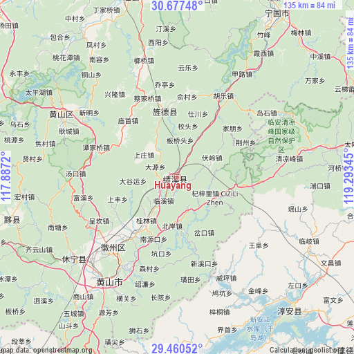
| Upper-left | 30.67748°, | 117.8872° |
| Center: | 30.07087°, | 118.59032° |
| Lower-right: | 29.46052°, | 119.29345° |
| Map W x H: | 135.3×135.3 km | = 84.1×84.1mi |
| max Lat: | 53.31946° ⇑53.3% North |
| Huayang: | 30.07087° |
| min Lat: | ⇓46.7% South 18.22056° |
| min Long | Huayang | max Long |
| 75.07348° | 118.59032° | 134.28917° |
| W 73.8%⇐ | ⇒26.2% E |
Elevation
Elevation of Huayang is 175 m = 574 ft, and this is 309.8 m = 1016 ft below average elevation for this country.
| Max E: |
5622 m = 18445 ft | 48.7% |
| Avg. | 484.8 m = 1591 ft | |
| Huayang | 175 m = 574 ft | |
Min E: |
-3 m = -10 ft | 51.3% |
See also: China elevation on elevation.city.
Geographical zone
Huayang is located in North temperate zone (between Tropic of Cancer and the Arctic Circle). Distance of this Northern Tropic circle is 737.6 km =458.3 mi to South.| Distance of | km | miles | from Huayang |
|---|---|---|---|
| North Pole | 6663.5 | 4140.5 | to North |
| Arctic Circle | 4057.6 | 2521.3 | to North |
| Tropic Cancer | 737.6 | 458.3 | to South |
| Equator | 3343.6 | 2077.6 | to South |


Nearby cities:
15 places around Huayang: (largest is in red/bold)
• Banqiaotou
14.4 km =8.9 mi,  3°
3°
• Bei’an
18 km =11.2 mi,  184°
184°
• Changxi
18.3 km =11.4 mi,  163°
163°
• Chang’an
11.4 km =7.1 mi,  322°
322°
• Daguyun
16.2 km =10.1 mi,  266°
266°
• Fuling
15.2 km =9.4 mi,  60°
60°
• Huangcun
19 km =11.8 mi,  250°
250°
• Linxi
10.4 km =6.5 mi,  210°
210°
• Qizili
16.4 km =10.2 mi,  118°
118°
• Shangzhuang
16.2 km =10.1 mi,  291°
291°
• Sucun
14.8 km =9.2 mi,  132°
132°
• Xiakeng
14.2 km =8.8 mi,  150°
150°
• Xitou
13.6 km =8.5 mi,  240°
240°
• Yangxi
10.8 km =6.7 mi,  27°
27°
• Yingzhou
5.3 km =3.3 mi,  101°
101°
Sources, notices
• [Note1] Compared only with cities in China existing in our database
• [Src1] Map data: © OpenStreetMap contributors (CC-BY-SA)
• [Src2] Other city data from geonames.org with taken over terms of usage.
• [Src3] Geographical zone / Annual Mean Temperature by Robert A. Rohde @ Wikipedia
