Villagómez geodata
Villagómez (Cundinamarca) is a seat of a second-order administrative division; located in Colombia in America/Bogota (GMT-5) time zone. With population of 779 people, there are 984 cities with bigger population in this country. Compared to other cities in Colombia, 55.6% of cities are located further ↑North; 62% of cities are located further ←West and 67.8% of cities have lower elevation than Villagómez. Note1


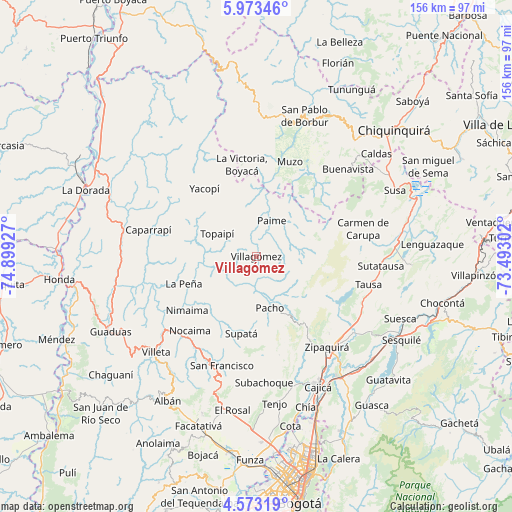
Villagómez GPS coordinates[2]
5° 16' 25.392" North, 74° 11' 46.104" West
| Map corner | latitude | longitude |
|---|---|---|
| Upper-left | 5.97346°, | -74.89927° |
| Center: | 5.27372°, | -74.19614° |
| Lower-right: | 4.57319°, | -73.49302° |
| Map W x H: | 155.7×155.7 km | = 96.7×96.7mi |
| max Lat: | 13.38166° ⇑55.6% North |
| Villagómez: | 5.27372° |
| min Lat: | ⇓44.4% South -4.21528° |
| min Long | Villagómez | max Long |
| -81.70636° | -74.19614° | -67.06996° |
| W 62%⇐ | ⇒38% E |
Elevation
Elevation of Villagómez is 1667 m = 5469 ft, and this is 517.7 m = 1698 ft above average elevation for this country.
| Max E: |
3342 m = 10965 ft | 32.2% |
| Villagómez | 1667 m 5469 ft | |
| Avg. | 1149.3 m = 3771 ft | |
Min E: |
1 m = 3 ft | 67.8% |
See also: Colombia elevation on elevation.city.
Geographical zone
Villagómez is located in North Torrid zone (between Equator and Tropic of Cancer). Distance of Equator is 586.4 km =364.4 mi to South.| Distance of | km | miles | from Villagómez |
|---|---|---|---|
| North Pole | 9420.7 | 5853.7 | to North |
| Arctic Circle | 6814.8 | 4234.5 | to North |
| Tropic Cancer | 2019.5 | 1254.9 | to North |
| Equator | 586.4 | 364.4 | to South |


Nearby cities:
15 places around Villagómez: (largest is in red/bold)
• Coper
28.2 km =17.5 mi,  36°
36°
• El Peñón
10.7 km =6.6 mi,  257°
257°
• La Palma
23.5 km =14.6 mi,  293°
293°
• La Peña
23.4 km =14.5 mi,  249°
249°
• La Victoria
28.4 km =17.6 mi,  351°
351°
• Nimaima
26.6 km =16.5 mi,  231°
231°
• Pacho
16.2 km =10.1 mi,  165°
165°
• Paime
11.8 km =7.3 mi,  24°
24°
• Quípama
27.4 km =17 mi,  4°
4°
• San Cayetano
14.4 km =8.9 mi,  77°
77°
• San Cayetano
20 km =12.4 mi,  69°
69°
• Supatá
24.1 km =15 mi,  190°
190°
• Topaipí
13.6 km =8.5 mi,  299°
299°
• Vergara
23.9 km =14.9 mi,  223°
223°
• Yacopí
26 km =16.2 mi,  322°
322°
Sources, notices
• [Note1] Compared only with cities in Colombia existing in our database
• [Src1] Map data: © OpenStreetMap contributors (CC-BY-SA)
• [Src2] Other city data from geonames.org with taken over terms of usage.
• [Src3] Geographical zone / Annual Mean Temperature by Robert A. Rohde @ Wikipedia
