Paime geodata
Paime (Cundinamarca) is a seat of a second-order administrative division; located in Colombia in America/Bogota (GMT-5) time zone. With population of 799 people, there are 980 cities with bigger population in this country. Compared to other cities in Colombia, 53.1% of cities are located further ↑North; 62.7% of cities are located further ←West and 50% of cities have lower elevation than Paime. Note1


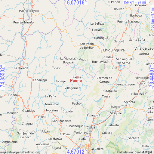
Paime GPS coordinates[2]
5° 22' 13.944" North, 74° 9' 7.884" West
| Map corner | latitude | longitude |
|---|---|---|
| Upper-left | 6.07016°, | -74.85532° |
| Center: | 5.37054°, | -74.15219° |
| Lower-right: | 4.67012°, | -73.44907° |
| Map W x H: | 155.7×155.7 km | = 96.7×96.7mi |
| max Lat: | 13.38166° ⇑53.1% North |
| Paime: | 5.37054° |
| min Lat: | ⇓46.9% South -4.21528° |
| min Long | Paime | max Long |
| -81.70636° | -74.15219° | -67.06996° |
| W 62.7%⇐ | ⇒37.3% E |
Elevation
Elevation of Paime is 1121 m = 3678 ft, and this is 28.3 m = 93 ft below average elevation for this country.
| Max E: |
3342 m = 10965 ft | 50% |
| Avg. | 1149.3 m = 3771 ft | |
| Paime | 1121 m = 3678 ft | |
Min E: |
1 m = 3 ft | 50% |
See also: Colombia elevation on elevation.city.
Geographical zone
Paime is located in North Torrid zone (between Equator and Tropic of Cancer). Distance of Equator is 597.1 km =371 mi to South.| Distance of | km | miles | from Paime |
|---|---|---|---|
| North Pole | 9409.9 | 5847 | to North |
| Arctic Circle | 6804 | 4227.8 | to North |
| Tropic Cancer | 2008.8 | 1248.2 | to North |
| Equator | 597.1 | 371 | to South |


Nearby cities:
15 places around Paime: (largest is in red/bold)
• Buenavista
27.5 km =17.1 mi,  54°
54°
• Carmen de Carupa
27.8 km =17.3 mi,  95°
95°
• Coper
16.8 km =10.4 mi, 45°
• El Peñón
20.2 km =12.6 mi,  229°
229°
• La Palma
26.4 km =16.4 mi,  267°
267°
• La Victoria
19.6 km =12.2 mi,  331°
331°
• Maripí
25.7 km =16 mi,  38°
38°
• Muzo
19 km =11.8 mi,  15°
15°
• Pacho
26.4 km =16.4 mi,  181°
181°
• Quípama
16.8 km =10.4 mi,  350°
350°
• San Cayetano
11.9 km =7.4 mi,  129°
129°
• San Cayetano
14.4 km =8.9 mi,  105°
105°
• Topaipí
17.2 km =10.7 mi,  256°
256°
• Villagómez
11.8 km =7.3 mi,  204°
204°
• Yacopí
22.8 km =14.2 mi,  295°
295°
Sources, notices
• [Note1] Compared only with cities in Colombia existing in our database
• [Src1] Map data: © OpenStreetMap contributors (CC-BY-SA)
• [Src2] Other city data from geonames.org with taken over terms of usage.
• [Src3] Geographical zone / Annual Mean Temperature by Robert A. Rohde @ Wikipedia
