La Estrella geodata
La Estrella (Antioquia) is a seat of a second-order administrative division; located in Colombia in America/Bogota (GMT-5) time zone. With population of 49,386 people, there are 83 cities with bigger population in this country. Compared to other cities in Colombia, 62.4% of cities are located further ↓South; 70.4% of cities are located further →East and 71.4% of cities have lower elevation than La Estrella. Note1


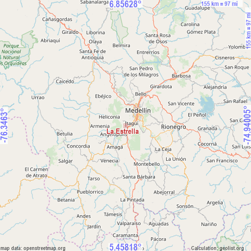
La Estrella GPS coordinates[2]
6° 9' 27.684" North, 75° 38' 35.412" West
| Map corner | latitude | longitude |
|---|---|---|
| Upper-left | 6.85628°, | -76.3463° |
| Center: | 6.15769°, | -75.64317° |
| Lower-right: | 5.45818°, | -74.94005° |
| Map W x H: | 155.5×155.5 km | = 96.6×96.6mi |
| max Lat: | 13.38166° ⇑37.6% North |
| La Estrella: | 6.15769° |
| min Lat: | ⇓62.4% South -4.21528° |
| min Long | La Estrella | max Long |
| -81.70636° | -75.64317° | -67.06996° |
| W 29.6%⇐ | ⇒70.4% E |
Elevation
Elevation of La Estrella is 1765 m = 5791 ft, and this is 615.7 m = 2020 ft above average elevation for this country.
| Max E: |
3342 m = 10965 ft | 28.6% |
| La Estrella | 1765 m 5791 ft | |
| Avg. | 1149.3 m = 3771 ft | |
Min E: |
1 m = 3 ft | 71.4% |
See also: La Estrella elevation on elevation.city.
Geographical zone
La Estrella is located in North Torrid zone (between Equator and Tropic of Cancer). Distance of Equator is 684.7 km =425.5 mi to South.| Distance of | km | miles | from La Estrella |
|---|---|---|---|
| North Pole | 9322.4 | 5792.7 | to North |
| Arctic Circle | 6716.5 | 4173.4 | to North |
| Tropic Cancer | 1921.2 | 1193.8 | to North |
| Equator | 684.7 | 425.5 | to South |


Nearby cities:
15 places around La Estrella: (largest is in red/bold)
• Amagá
14.7 km =9.1 mi,  206°
206°
• Angelópolis
9 km =5.6 mi,  234°
234°
• Armenia
15.9 km =9.9 mi,  269°
269°
• Bello
22.1 km =13.7 mi,  25°
25°
• Caldas
7.5 km =4.7 mi,  173°
173°
• Copacabana
25.7 km =16 mi,  35°
35°
• Ebéjico
23.3 km =14.5 mi,  323°
323°
• Envigado
6 km =3.7 mi,  70°
70°
• Heliconia
11.7 km =7.3 mi,  298°
298°
• Itagüí
5.7 km =3.5 mi,  58°
58°
• Medellín
13.7 km =8.5 mi, 40°
• Retiro
19 km =11.8 mi,  125°
125°
• Sabaneta
3 km =1.9 mi,  103°
103°
• Titiribí
19.7 km =12.2 mi,  237°
237°
• Venecia
24.1 km =15 mi, 205°
Sources, notices
• [Note1] Compared only with cities in Colombia existing in our database
• [Src1] Map data: © OpenStreetMap contributors (CC-BY-SA)
• [Src2] Other city data from geonames.org with taken over terms of usage.
• [Src3] Geographical zone / Annual Mean Temperature by Robert A. Rohde @ Wikipedia
