Sucre geodata
Sucre is a seat of a second-order administrative division; located in Colombia in America/Bogota (GMT-5) time zone. With population of 23,210 people, there are 156 cities with bigger population in this country. Compared to other cities in Colombia, 85.6% of cities are located further ↓South; 52.6% of cities are located further ←West and 93.4% of cities have higher elevation than Sucre. Note1


Sucre GPS coordinates[2]
8° 48' 40.896" North, 74° 43' 15.024" West
| Map corner | latitude | longitude |
|---|---|---|
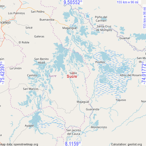
| Upper-left | 9.50552°, | -75.42397° |
| Center: | 8.81136°, | -74.72084° |
| Lower-right: | 8.1159°, | -74.01772° |
| Map W x H: | 154.5×154.5 km | = 96×96mi |
| max Lat: | 13.38166° ⇑14.4% North |
| Sucre: | 8.81136° |
| min Lat: | ⇓85.6% South -4.21528° |
| min Long | Sucre | max Long |
| -81.70636° | -74.72084° | -67.06996° |
| W 52.6%⇐ | ⇒47.4% E |
Elevation
Elevation of Sucre is 18 m = 59 ft, and this is 1131.3 m = 3712 ft below average elevation for this country.
| Max E: |
3342 m = 10965 ft | 93.4% |
| Avg. | 1149.3 m = 3771 ft | |
| Sucre | 18 m = 59 ft | |
Min E: |
1 m = 3 ft | 6.6% |
See also: Colombia elevation on elevation.city.
Geographical zone
Sucre is located in North Torrid zone (between Equator and Tropic of Cancer). Distance of Equator is 979.7 km =608.8 mi to South.| Distance of | km | miles | from Sucre |
|---|---|---|---|
| North Pole | 9027.3 | 5609.3 | to North |
| Arctic Circle | 6421.4 | 3990.1 | to North |
| Tropic Cancer | 1626.2 | 1010.5 | to North |
| Equator | 979.7 | 608.8 | to South |


Nearby cities:
15 places around Sucre: (largest is in red/bold)
• Achí
32.4 km =20.1 mi,  146°
146°
• Caimito
43.6 km =27.1 mi,  266°
266°
• Cicuco
52.5 km =32.6 mi,  9°
9°
• Galeras
52.9 km =32.9 mi,  317°
317°
• Guaranda
43.3 km =26.9 mi, 152°
• Magangué
48 km =29.8 mi,  355°
355°
• Majagual
31.7 km =19.7 mi,  161°
161°
• Pinillos
30.3 km =18.8 mi,  66°
66°
• San Benito Abad
36.1 km =22.4 mi,  291°
291°
• San Fernando
56 km =34.8 mi,  21°
21°
• San Marcos
47.8 km =29.7 mi,  249°
249°
• San Zenón
53.7 km =33.4 mi,  26°
26°
• Talaigua Nuevo
57.3 km =35.6 mi, 17°
• Talaigua Viejo
57.6 km =35.8 mi, 14°
• Tiquisio
57.7 km =35.9 mi,  119°
119°
Sources, notices
• [Note1] Compared only with cities in Colombia existing in our database
• [Src1] Map data: © OpenStreetMap contributors (CC-BY-SA)
• [Src2] Other city data from geonames.org with taken over terms of usage.
• [Src3] Geographical zone / Annual Mean Temperature by Robert A. Rohde @ Wikipedia
