Achí geodata
Achí (Bolívar) is a seat of a second-order administrative division; located in Colombia in America/Bogota (GMT-5) time zone. With population of 8,434 people, there are 353 cities with bigger population in this country. Compared to other cities in Colombia, 84.3% of cities are located further ↓South; 55.9% of cities are located further ←West and 91.8% of cities have higher elevation than Achí. Note1


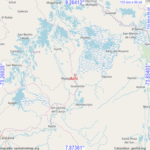
Achí GPS coordinates[2]
8° 34' 10.2" North, 74° 33' 25.74" West
| Map corner | latitude | longitude |
|---|---|---|
| Upper-left | 9.26412°, | -75.26028° |
| Center: | 8.5695°, | -74.55715° |
| Lower-right: | 7.87361°, | -73.85403° |
| Map W x H: | 154.6×154.6 km | = 96.1×96.1mi |
| max Lat: | 13.38166° ⇑15.7% North |
| Achí: | 8.5695° |
| min Lat: | ⇓84.3% South -4.21528° |
| min Long | Achí | max Long |
| -81.70636° | -74.55715° | -67.06996° |
| W 55.9%⇐ | ⇒44.1% E |
Elevation
Elevation of Achí is 23 m = 75 ft, and this is 1126.3 m = 3695 ft below average elevation for this country.
| Max E: |
3342 m = 10965 ft | 91.8% |
| Avg. | 1149.3 m = 3771 ft | |
| Achí | 23 m = 75 ft | |
Min E: |
1 m = 3 ft | 8.2% |
See also: Colombia elevation on elevation.city.
Geographical zone
Achí is located in North Torrid zone (between Equator and Tropic of Cancer). Distance of Equator is 952.8 km =592 mi to South.| Distance of | km | miles | from Achí |
|---|---|---|---|
| North Pole | 9054.2 | 5626 | to North |
| Arctic Circle | 6448.3 | 4006.8 | to North |
| Tropic Cancer | 1653.1 | 1027.2 | to North |
| Equator | 952.8 | 592 | to South |


Nearby cities:
15 places around Achí: (largest is in red/bold)
• Altos del Rosario
49.6 km =30.8 mi,  60°
60°
• Barranco de Loba
64.8 km =40.3 mi,  49°
49°
• Caimito
66.2 km =41.1 mi,  291°
291°
• Guaranda
11.6 km =7.2 mi,  168°
168°
• Majagual
8.5 km =5.3 mi,  248°
248°
• Montecristo
31.7 km =19.7 mi,  163°
163°
• Nechí
58.1 km =36.1 mi,  204°
204°
• Norosí
57.3 km =35.6 mi,  94°
94°
• Pinillos
40.1 km =24.9 mi,  14°
14°
• Pueblo Nuevo
57.3 km =35.6 mi,  230°
230°
• San Benito Abad
65.3 km =40.6 mi,  307°
307°
• San Jacinto del Cauca
39.8 km =24.7 mi,  206°
206°
• San Marcos
63.6 km =39.5 mi,  279°
279°
• Sucre
32.4 km =20.1 mi,  326°
326°
• Tiquisio
32.3 km =20.1 mi, 92°
Sources, notices
• [Note1] Compared only with cities in Colombia existing in our database
• [Src1] Map data: © OpenStreetMap contributors (CC-BY-SA)
• [Src2] Other city data from geonames.org with taken over terms of usage.
• [Src3] Geographical zone / Annual Mean Temperature by Robert A. Rohde @ Wikipedia
