Majagual geodata
Majagual (Sucre) is a seat of a second-order administrative division; located in Colombia in America/Bogota (GMT-5) time zone. With population of 11,139 people, there are 276 cities with bigger population in this country. Compared to other cities in Colombia, 84.1% of cities are located further ↓South; 54.4% of cities are located further ←West and 90.2% of cities have higher elevation than Majagual. Note1


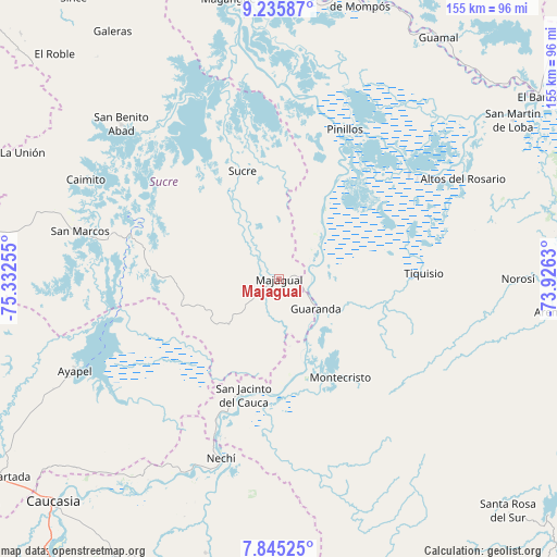
Majagual GPS coordinates[2]
8° 32' 28.284" North, 74° 37' 45.912" West
| Map corner | latitude | longitude |
|---|---|---|
| Upper-left | 9.23587°, | -75.33255° |
| Center: | 8.54119°, | -74.62942° |
| Lower-right: | 7.84525°, | -73.9263° |
| Map W x H: | 154.6×154.6 km | = 96.1×96.1mi |
| max Lat: | 13.38166° ⇑15.9% North |
| Majagual: | 8.54119° |
| min Lat: | ⇓84.1% South -4.21528° |
| min Long | Majagual | max Long |
| -81.70636° | -74.62942° | -67.06996° |
| W 54.4%⇐ | ⇒45.6% E |
Elevation
Elevation of Majagual is 29 m = 95 ft, and this is 1120.3 m = 3676 ft below average elevation for this country.
| Max E: |
3342 m = 10965 ft | 90.2% |
| Avg. | 1149.3 m = 3771 ft | |
| Majagual | 29 m = 95 ft | |
Min E: |
1 m = 3 ft | 9.8% |
See also: Colombia elevation on elevation.city.
Geographical zone
Majagual is located in North Torrid zone (between Equator and Tropic of Cancer). Distance of Equator is 949.7 km =590.1 mi to South.| Distance of | km | miles | from Majagual |
|---|---|---|---|
| North Pole | 9057.4 | 5628 | to North |
| Arctic Circle | 6451.5 | 4008.8 | to North |
| Tropic Cancer | 1656.2 | 1029.1 | to North |
| Equator | 949.7 | 590.1 | to South |


Nearby cities:
15 places around Majagual: (largest is in red/bold)
• Achí
8.5 km =5.3 mi,  68°
68°
• Altos del Rosario
58.1 km =36.1 mi,  61°
61°
• Ayapel
61.6 km =38.3 mi,  245°
245°
• Caimito
60.3 km =37.5 mi,  297°
297°
• Guaranda
13.1 km =8.1 mi,  128°
128°
• Montecristo
32.1 km =19.9 mi,  147°
147°
• Nechí
52.2 km =32.4 mi,  197°
197°
• Norosí
65.1 km =40.5 mi,  91°
91°
• Pinillos
45.6 km =28.3 mi,  22°
22°
• Pueblo Nuevo
49.2 km =30.6 mi,  227°
227°
• San Benito Abad
61.4 km =38.2 mi,  314°
314°
• San Jacinto del Cauca
33.9 km =21.1 mi, 197°
• San Marcos
56.4 km =35 mi,  283°
283°
• Sucre
31.7 km =19.7 mi,  341°
341°
• Tiquisio
40.3 km =25 mi, 87°
Sources, notices
• [Note1] Compared only with cities in Colombia existing in our database
• [Src1] Map data: © OpenStreetMap contributors (CC-BY-SA)
• [Src2] Other city data from geonames.org with taken over terms of usage.
• [Src3] Geographical zone / Annual Mean Temperature by Robert A. Rohde @ Wikipedia
