Silvania geodata
Silvania (Cundinamarca) is a seat of a second-order administrative division; located in Colombia in America/Bogota (GMT-5) time zone. With population of 8,237 people, there are 360 cities with bigger population in this country. Compared to other cities in Colombia, 72.7% of cities are located further ↑North; 58.9% of cities are located further ←West and 59.9% of cities have lower elevation than Silvania. Note1


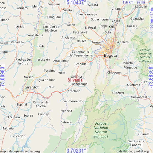
Silvania GPS coordinates[2]
4° 24' 13.212" North, 74° 23' 12.12" West
| Map corner | latitude | longitude |
|---|---|---|
| Upper-left | 5.10437°, | -75.08983° |
| Center: | 4.40367°, | -74.3867° |
| Lower-right: | 3.70231°, | -73.68358° |
| Map W x H: | 155.9×155.9 km | = 96.9×96.9mi |
| max Lat: | 13.38166° ⇑72.7% North |
| Silvania: | 4.40367° |
| min Lat: | ⇓27.3% South -4.21528° |
| min Long | Silvania | max Long |
| -81.70636° | -74.3867° | -67.06996° |
| W 58.9%⇐ | ⇒41.1% E |
Elevation
Elevation of Silvania is 1459 m = 4787 ft, and this is 309.7 m = 1016 ft above average elevation for this country.
| Max E: |
3342 m = 10965 ft | 40.1% |
| Silvania | 1459 m 4787 ft | |
| Avg. | 1149.3 m = 3771 ft | |
Min E: |
1 m = 3 ft | 59.9% |
See also: Colombia elevation on elevation.city.
Geographical zone
Silvania is located in North Torrid zone (between Equator and Tropic of Cancer). Distance of Equator is 489.6 km =304.2 mi to South.| Distance of | km | miles | from Silvania |
|---|---|---|---|
| North Pole | 9517.4 | 5913.8 | to North |
| Arctic Circle | 6911.5 | 4294.6 | to North |
| Tropic Cancer | 2116.3 | 1315 | to North |
| Equator | 489.6 | 304.2 | to South |


Nearby cities:
15 places around Silvania: (largest is in red/bold)
• Anapoima
23.2 km =14.4 mi,  314°
314°
• Apulo
26.2 km =16.3 mi,  299°
299°
• Arbeláez
14.9 km =9.3 mi,  192°
192°
• El Colegio
20.7 km =12.9 mi,  342°
342°
• Fusagasugá
7.9 km =4.9 mi,  161°
161°
• Granada
13.5 km =8.4 mi,  16°
16°
• Nilo
28.1 km =17.5 mi,  247°
247°
• Pandi
26.1 km =16.2 mi,  205°
205°
• Pasca
14.4 km =8.9 mi,  138°
138°
• San Antonio del Tequendama
23.9 km =14.9 mi,  9°
9°
• San Bernardo
25.3 km =15.7 mi, 189°
• Sibaté
17.1 km =10.6 mi,  55°
55°
• Soacha
27.1 km =16.8 mi,  43°
43°
• Tibacuy
9.4 km =5.8 mi,  230°
230°
• Viotá
15.4 km =9.6 mi,  283°
283°
Sources, notices
• [Note1] Compared only with cities in Colombia existing in our database
• [Src1] Map data: © OpenStreetMap contributors (CC-BY-SA)
• [Src2] Other city data from geonames.org with taken over terms of usage.
• [Src3] Geographical zone / Annual Mean Temperature by Robert A. Rohde @ Wikipedia
