Soacha geodata
Soacha (Cundinamarca) is a seat of a second-order administrative division; located in Colombia in America/Bogota (GMT-5) time zone. With population of 313,945 people, there are 17 cities with bigger population in this country. Compared to other cities in Colombia, 69.9% of cities are located further ↑North; 61.7% of cities are located further ←West and 91.2% of cities have lower elevation than Soacha. Note1


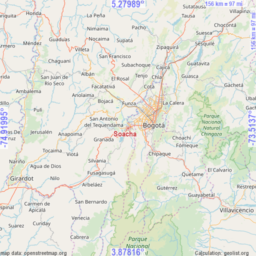
Soacha GPS coordinates[2]
4° 34' 45.732" North, 74° 13' 0.552" West
| Map corner | latitude | longitude |
|---|---|---|
| Upper-left | 5.27989°, | -74.91995° |
| Center: | 4.57937°, | -74.21682° |
| Lower-right: | 3.87816°, | -73.5137° |
| Map W x H: | 155.9×155.9 km | = 96.9×96.9mi |
| max Lat: | 13.38166° ⇑69.9% North |
| Soacha: | 4.57937° |
| min Lat: | ⇓30.1% South -4.21528° |
| min Long | Soacha | max Long |
| -81.70636° | -74.21682° | -67.06996° |
| W 61.7%⇐ | ⇒38.3% E |
Elevation
Elevation of Soacha is 2565 m = 8415 ft, and this is 1415.7 m = 4645 ft above average elevation for this country.
| Max E: |
3342 m = 10965 ft | 8.8% |
| Soacha | 2565 m 8415 ft | |
| Avg. | 1149.3 m = 3771 ft | |
Min E: |
1 m = 3 ft | 91.2% |
See also: Soacha elevation on elevation.city.
Geographical zone
Soacha is located in North Torrid zone (between Equator and Tropic of Cancer). Distance of Equator is 509.2 km =316.4 mi to South.| Distance of | km | miles | from Soacha |
|---|---|---|---|
| North Pole | 9497.9 | 5901.7 | to North |
| Arctic Circle | 6892 | 4282.5 | to North |
| Tropic Cancer | 2096.7 | 1302.8 | to North |
| Equator | 509.2 | 316.4 | to South |


Nearby cities:
15 places around Soacha: (largest is in red/bold)
• Barrio San Luis
23.8 km =14.8 mi,  65°
65°
• Bogotá
15.3 km =9.5 mi,  77°
77°
• Bojacá
21.8 km =13.5 mi,  320°
320°
• Chipaque
24.5 km =15.2 mi,  128°
128°
• Cota
28.8 km =17.9 mi,  27°
27°
• El Colegio
25.1 km =15.6 mi,  270°
270°
• Funza
15.2 km =9.4 mi,  2°
2°
• Granada
16.4 km =10.2 mi,  246°
246°
• Madrid
17.8 km =11.1 mi,  342°
342°
• Mosquera
14.1 km =8.8 mi,  353°
353°
• San Antonio del Tequendama
15.5 km =9.6 mi,  285°
285°
• Sibaté
10.9 km =6.8 mi,  205°
205°
• Silvania
27.1 km =16.8 mi,  223°
223°
• Tena
21.4 km =13.3 mi, 294°
• Zipacón
26.9 km =16.7 mi, 317°
Sources, notices
• [Note1] Compared only with cities in Colombia existing in our database
• [Src1] Map data: © OpenStreetMap contributors (CC-BY-SA)
• [Src2] Other city data from geonames.org with taken over terms of usage.
• [Src3] Geographical zone / Annual Mean Temperature by Robert A. Rohde @ Wikipedia
