Pasca geodata
Pasca (Cundinamarca) is a seat of a second-order administrative division; located in Colombia in America/Bogota (GMT-5) time zone. With population of 3,169 people, there are 666 cities with bigger population in this country. Compared to other cities in Colombia, 74.5% of cities are located further ↑North; 60.3% of cities are located further ←West and 83.8% of cities have lower elevation than Pasca. Note1


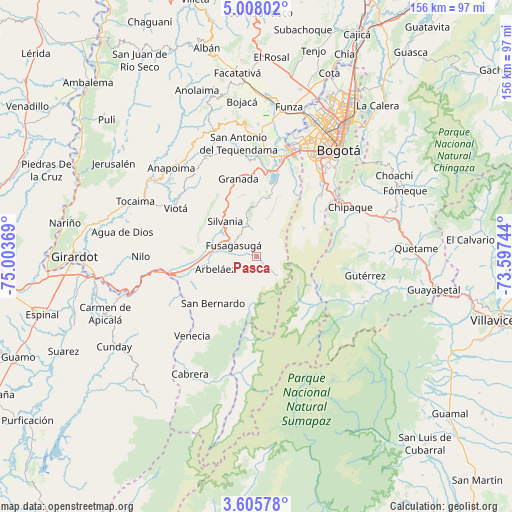
Pasca GPS coordinates[2]
4° 18' 25.992" North, 74° 18' 2.016" West
| Map corner | latitude | longitude |
|---|---|---|
| Upper-left | 5.00802°, | -75.00369° |
| Center: | 4.30722°, | -74.30056° |
| Lower-right: | 3.60578°, | -73.59744° |
| Map W x H: | 155.9×155.9 km | = 96.9×96.9mi |
| max Lat: | 13.38166° ⇑74.5% North |
| Pasca: | 4.30722° |
| min Lat: | ⇓25.5% South -4.21528° |
| min Long | Pasca | max Long |
| -81.70636° | -74.30056° | -67.06996° |
| W 60.3%⇐ | ⇒39.7% E |
Elevation
Elevation of Pasca is 2183 m = 7162 ft, and this is 1033.7 m = 3391 ft above average elevation for this country.
| Max E: |
3342 m = 10965 ft | 16.2% |
| Pasca | 2183 m 7162 ft | |
| Avg. | 1149.3 m = 3771 ft | |
Min E: |
1 m = 3 ft | 83.8% |
See also: Colombia elevation on elevation.city.
Geographical zone
Pasca is located in North Torrid zone (between Equator and Tropic of Cancer). Distance of Equator is 478.9 km =297.6 mi to South.| Distance of | km | miles | from Pasca |
|---|---|---|---|
| North Pole | 9528.1 | 5920.5 | to North |
| Arctic Circle | 6922.3 | 4301.3 | to North |
| Tropic Cancer | 2127 | 1321.7 | to North |
| Equator | 478.9 | 297.6 | to South |


Nearby cities:
15 places around Pasca: (largest is in red/bold)
• Arbeláez
13.3 km =8.3 mi,  253°
253°
• Chipaque
32.2 km =20 mi,  62°
62°
• Fusagasugá
7.7 km =4.8 mi,  294°
294°
• Granada
24.3 km =15.1 mi,  346°
346°
• Gutiérrez
33.6 km =20.9 mi,  100°
100°
• Icononzo
29.5 km =18.3 mi,  240°
240°
• Pandi
24.4 km =15.2 mi, 238°
• San Bernardo
19.7 km =12.2 mi,  223°
223°
• Sibaté
21 km =13 mi,  12°
12°
• Silvania
14.4 km =8.9 mi,  318°
318°
• Soacha
31.7 km =19.7 mi,  17°
17°
• Tibacuy
17.4 km =10.8 mi, 285°
• Une
32.3 km =20.1 mi,  70°
70°
• Venecia
31.3 km =19.4 mi, 218°
• Viotá
28.4 km =17.6 mi,  300°
300°
Sources, notices
• [Note1] Compared only with cities in Colombia existing in our database
• [Src1] Map data: © OpenStreetMap contributors (CC-BY-SA)
• [Src2] Other city data from geonames.org with taken over terms of usage.
• [Src3] Geographical zone / Annual Mean Temperature by Robert A. Rohde @ Wikipedia
