Pandi geodata
Pandi (Cundinamarca) is a seat of a second-order administrative division; located in Colombia in America/Bogota (GMT-5) time zone. With population of 1,336 people, there are 896 cities with bigger population in this country. Compared to other cities in Colombia, 76.5% of cities are located further ↑North; 56.8% of cities are located further ←West and 57.4% of cities have higher elevation than Pandi. Note1


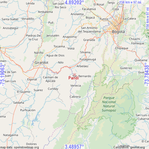
Pandi GPS coordinates[2]
4° 11' 27.996" North, 74° 29' 15" West
| Map corner | latitude | longitude |
|---|---|---|
| Upper-left | 4.89202°, | -75.19063° |
| Center: | 4.19111°, | -74.4875° |
| Lower-right: | 3.48957°, | -73.78438° |
| Map W x H: | 155.9×155.9 km | = 96.9×96.9mi |
| max Lat: | 13.38166° ⇑76.5% North |
| Pandi: | 4.19111° |
| min Lat: | ⇓23.5% South -4.21528° |
| min Long | Pandi | max Long |
| -81.70636° | -74.4875° | -67.06996° |
| W 56.8%⇐ | ⇒43.2% E |
Elevation
Elevation of Pandi is 922 m = 3025 ft, and this is 227.3 m = 746 ft below average elevation for this country.
| Max E: |
3342 m = 10965 ft | 57.4% |
| Avg. | 1149.3 m = 3771 ft | |
| Pandi | 922 m = 3025 ft | |
Min E: |
1 m = 3 ft | 42.6% |
See also: Colombia elevation on elevation.city.
Geographical zone
Pandi is located in North Torrid zone (between Equator and Tropic of Cancer). Distance of Equator is 466 km =289.6 mi to South.| Distance of | km | miles | from Pandi |
|---|---|---|---|
| North Pole | 9541.1 | 5928.6 | to North |
| Arctic Circle | 6935.2 | 4309.3 | to North |
| Tropic Cancer | 2139.9 | 1329.7 | to North |
| Equator | 466 | 289.6 | to South |


Nearby cities:
15 places around Pandi: (largest is in red/bold)
• Agua de Dios
28.9 km =18 mi,  315°
315°
• Arbeláez
12.1 km =7.5 mi,  41°
41°
• Cabrera
22.8 km =14.2 mi,  178°
178°
• Carmen de Apicalá
26.3 km =16.3 mi,  259°
259°
• Cunday
27 km =16.8 mi,  237°
237°
• Fusagasugá
21.2 km =13.2 mi, 40°
• Icononzo
5.2 km =3.2 mi,  252°
252°
• Melgar
17.1 km =10.6 mi,  275°
275°
• Nilo
19.5 km =12.1 mi,  310°
310°
• Pasca
24.4 km =15.2 mi,  58°
58°
• San Bernardo
7.3 km =4.5 mi,  100°
100°
• Silvania
26.1 km =16.2 mi,  25°
25°
• Tibacuy
18.1 km =11.2 mi,  12°
12°
• Venecia
11.5 km =7.1 mi,  174°
174°
• Viotá
27.6 km =17.1 mi,  352°
352°
Sources, notices
• [Note1] Compared only with cities in Colombia existing in our database
• [Src1] Map data: © OpenStreetMap contributors (CC-BY-SA)
• [Src2] Other city data from geonames.org with taken over terms of usage.
• [Src3] Geographical zone / Annual Mean Temperature by Robert A. Rohde @ Wikipedia
