Retiro geodata
Retiro (Antioquia) is a seat of a second-order administrative division; located in Colombia in America/Bogota (GMT-5) time zone. With population of 7,941 people, there are 374 cities with bigger population in this country. Compared to other cities in Colombia, 60.6% of cities are located further ↓South; 66.2% of cities are located further →East and 83.3% of cities have lower elevation than Retiro. Note1


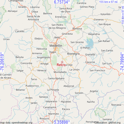
Retiro GPS coordinates[2]
6° 3' 30.996" North, 75° 30' 11.016" West
| Map corner | latitude | longitude |
|---|---|---|
| Upper-left | 6.75734°, | -76.20619° |
| Center: | 6.05861°, | -75.50306° |
| Lower-right: | 5.35898°, | -74.79994° |
| Map W x H: | 155.5×155.5 km | = 96.6×96.6mi |
| max Lat: | 13.38166° ⇑39.4% North |
| Retiro: | 6.05861° |
| min Lat: | ⇓60.6% South -4.21528° |
| min Long | Retiro | max Long |
| -81.70636° | -75.50306° | -67.06996° |
| W 33.8%⇐ | ⇒66.2% E |
Elevation
Elevation of Retiro is 2166 m = 7106 ft, and this is 1016.7 m = 3336 ft above average elevation for this country.
| Max E: |
3342 m = 10965 ft | 16.7% |
| Retiro | 2166 m 7106 ft | |
| Avg. | 1149.3 m = 3771 ft | |
Min E: |
1 m = 3 ft | 83.3% |
See also: Colombia elevation on elevation.city.
Geographical zone
Retiro is located in North Torrid zone (between Equator and Tropic of Cancer). Distance of Equator is 673.7 km =418.6 mi to South.| Distance of | km | miles | from Retiro |
|---|---|---|---|
| North Pole | 9333.4 | 5799.5 | to North |
| Arctic Circle | 6727.5 | 4180.3 | to North |
| Tropic Cancer | 1932.3 | 1200.7 | to North |
| Equator | 673.7 | 418.6 | to South |


Nearby cities:
15 places around Retiro: (largest is in red/bold)
• Amagá
22.2 km =13.8 mi,  264°
264°
• Angelópolis
23.5 km =14.6 mi,  284°
284°
• Caldas
15.1 km =9.4 mi, 283°
• Carmen de Viboral
18.8 km =11.7 mi,  81°
81°
• Envigado
16.3 km =10.1 mi,  323°
323°
• Itagüí
17.6 km =10.9 mi, 322°
• La Ceja
8.3 km =5.2 mi,  111°
111°
• La Estrella
19 km =11.8 mi,  305°
305°
• La Unión
18.2 km =11.3 mi,  120°
120°
• Marinilla
22.4 km =13.9 mi,  55°
55°
• Medellín
22.5 km =14 mi,  342°
342°
• Montebello
12.6 km =7.8 mi,  192°
192°
• Rionegro
17.9 km =11.1 mi,  53°
53°
• Sabaneta
16.3 km =10.1 mi, 309°
• Santa Bárbara
21.7 km =13.5 mi,  199°
199°
Sources, notices
• [Note1] Compared only with cities in Colombia existing in our database
• [Src1] Map data: © OpenStreetMap contributors (CC-BY-SA)
• [Src2] Other city data from geonames.org with taken over terms of usage.
• [Src3] Geographical zone / Annual Mean Temperature by Robert A. Rohde @ Wikipedia
