San Pablo geodata
San Pablo (Bolívar) is a populated place; located in Colombia in America/Bogota (GMT-5) time zone. With population of 13,983 people, there are 229 cities with bigger population in this country. Compared to other cities in Colombia, 93.2% of cities are located further ↓South; 60.8% of cities are located further →East and 94.9% of cities have higher elevation than San Pablo. Note1


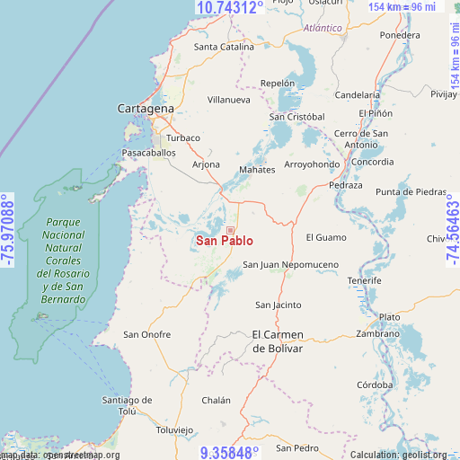
San Pablo GPS coordinates[2]
10° 3' 5.544" North, 75° 16' 3.9" West
| Map corner | latitude | longitude |
|---|---|---|
| Upper-left | 10.74312°, | -75.97088° |
| Center: | 10.05154°, | -75.26775° |
| Lower-right: | 9.35848°, | -74.56463° |
| Map W x H: | 154×154 km | = 95.7×95.7mi |
| max Lat: | 13.38166° ⇑6.8% North |
| San Pablo: | 10.05154° |
| min Lat: | ⇓93.2% South -4.21528° |
| min Long | San Pablo | max Long |
| -81.70636° | -75.26775° | -67.06996° |
| W 39.2%⇐ | ⇒60.8% E |
Elevation
Elevation of San Pablo is 14 m = 46 ft, and this is 1135.3 m = 3725 ft below average elevation for this country.
| Max E: |
3342 m = 10965 ft | 94.9% |
| Avg. | 1149.3 m = 3771 ft | |
| San Pablo | 14 m = 46 ft | |
Min E: |
1 m = 3 ft | 5.1% |
See also: Colombia elevation on elevation.city.
Geographical zone
San Pablo is located in North Torrid zone (between Equator and Tropic of Cancer). Distance of Equator is 1117.6 km =694.4 mi to South.| Distance of | km | miles | from San Pablo |
|---|---|---|---|
| North Pole | 8889.4 | 5523.6 | to North |
| Arctic Circle | 6283.5 | 3904.4 | to North |
| Tropic Cancer | 1488.3 | 924.8 | to North |
| Equator | 1117.6 | 694.4 | to South |


Nearby cities:
15 places around San Pablo: (largest is in red/bold)
• Arjona
24.1 km =15 mi,  339°
339°
• Arroyohondo
35.1 km =21.8 mi,  50°
50°
• El Carmen de Bolívar
40.5 km =25.2 mi,  156°
156°
• El Guamo
32 km =19.9 mi,  93°
93°
• Mahates
21.9 km =13.6 mi,  22°
22°
• María la Baja
8.5 km =5.3 mi,  205°
205°
• Pedraza
41.5 km =25.8 mi,  68°
68°
• San Cristóbal
19.4 km =12.1 mi,  175°
175°
• San Estanislao
40.6 km =25.2 mi, 18°
• San Jacinto
29.6 km =18.4 mi,  147°
147°
• San Juan Nepomuceno
23.2 km =14.4 mi,  118°
118°
• Soplaviento
40.4 km =25.1 mi, 20°
• Turbaco
34.7 km =21.6 mi,  333°
333°
• Turbaná
31 km =19.3 mi,  322°
322°
• Villanueva
43.6 km =27.1 mi,  359°
359°
Sources, notices
• [Note1] Compared only with cities in Colombia existing in our database
• [Src1] Map data: © OpenStreetMap contributors (CC-BY-SA)
• [Src2] Other city data from geonames.org with taken over terms of usage.
• [Src3] Geographical zone / Annual Mean Temperature by Robert A. Rohde @ Wikipedia
