Arjona geodata
Arjona (Bolívar) is a seat of a second-order administrative division; located in Colombia in America/Bogota (GMT-5) time zone. With population of 50,405 people, there are 82 cities with bigger population in this country. Compared to other cities in Colombia, 94.1% of cities are located further ↓South; 63% of cities are located further →East and 84.9% of cities have higher elevation than Arjona. Note1


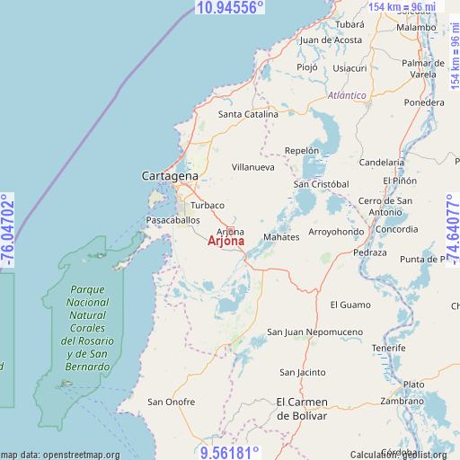
Arjona GPS coordinates[2]
10° 15' 15.984" North, 75° 20' 38.004" West
| Map corner | latitude | longitude |
|---|---|---|
| Upper-left | 10.94556°, | -76.04702° |
| Center: | 10.25444°, | -75.34389° |
| Lower-right: | 9.56181°, | -74.64077° |
| Map W x H: | 153.9×153.9 km | = 95.6×95.6mi |
| max Lat: | 13.38166° ⇑5.9% North |
| Arjona: | 10.25444° |
| min Lat: | ⇓94.1% South -4.21528° |
| min Long | Arjona | max Long |
| -81.70636° | -75.34389° | -67.06996° |
| W 37%⇐ | ⇒63% E |
Elevation
Elevation of Arjona is 62 m = 203 ft, and this is 1087.3 m = 3567 ft below average elevation for this country.
| Max E: |
3342 m = 10965 ft | 84.9% |
| Avg. | 1149.3 m = 3771 ft | |
| Arjona | 62 m = 203 ft | |
Min E: |
1 m = 3 ft | 15.1% |
See also: Arjona elevation on elevation.city.
Geographical zone
Arjona is located in North Torrid zone (between Equator and Tropic of Cancer). Distance of Equator is 1140.2 km =708.5 mi to South.| Distance of | km | miles | from Arjona |
|---|---|---|---|
| North Pole | 8866.9 | 5509.6 | to North |
| Arctic Circle | 6261 | 3890.4 | to North |
| Tropic Cancer | 1465.7 | 910.7 | to North |
| Equator | 1140.2 | 708.5 | to South |


Nearby cities:
15 places around Arjona: (largest is in red/bold)
• Arroyohondo
35.5 km =22.1 mi,  90°
90°
• Cartagena
24.7 km =15.3 mi,  310°
310°
• Clemencia
34.8 km =21.6 mi,  3°
3°
• Mahates
17 km =10.6 mi,  98°
98°
• María la Baja
30.5 km =19 mi,  171°
171°
• Repelón
36 km =22.4 mi,  41°
41°
• San Cristóbal
34.2 km =21.3 mi,  62°
62°
• San Estanislao
26.5 km =16.5 mi,  52°
52°
• San Pablo
24.1 km =15 mi,  159°
159°
• Santa Catalina
39.3 km =24.4 mi,  8°
8°
• Santa Rosa
21.3 km =13.2 mi,  352°
352°
• Soplaviento
27 km =16.8 mi, 55°
• Turbaco
11.1 km =6.9 mi,  318°
318°
• Turbaná
10.9 km =6.8 mi,  280°
280°
• Villanueva
22.4 km =13.9 mi,  20°
20°
Sources, notices
• [Note1] Compared only with cities in Colombia existing in our database
• [Src1] Map data: © OpenStreetMap contributors (CC-BY-SA)
• [Src2] Other city data from geonames.org with taken over terms of usage.
• [Src3] Geographical zone / Annual Mean Temperature by Robert A. Rohde @ Wikipedia
