María la Baja geodata
María la Baja (Bolívar) is a seat of a second-order administrative division; located in Colombia in America/Bogota (GMT-5) time zone. With population of 23,401 people, there are 155 cities with bigger population in this country. Compared to other cities in Colombia, 92.8% of cities are located further ↓South; 61.7% of cities are located further →East and 94.4% of cities have higher elevation than María la Baja. Note1


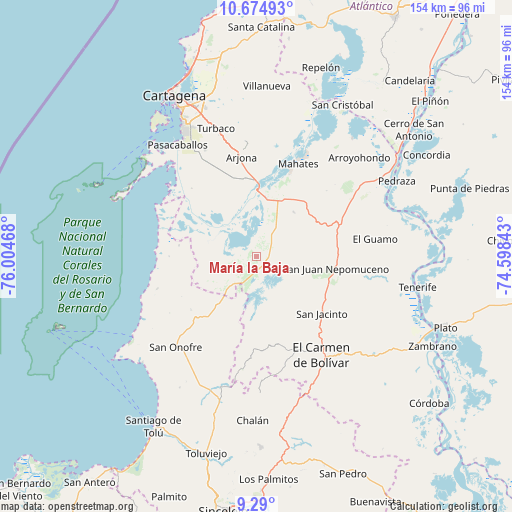
María la Baja GPS coordinates[2]
9° 58' 59.52" North, 75° 18' 5.58" West
| Map corner | latitude | longitude |
|---|---|---|
| Upper-left | 10.67493°, | -76.00468° |
| Center: | 9.9832°, | -75.30155° |
| Lower-right: | 9.29°, | -74.59843° |
| Map W x H: | 154×154 km | = 95.7×95.7mi |
| max Lat: | 13.38166° ⇑7.2% North |
| María la Baja: | 9.9832° |
| min Lat: | ⇓92.8% South -4.21528° |
| min Long | María la Baja | max Long |
| -81.70636° | -75.30155° | -67.06996° |
| W 38.3%⇐ | ⇒61.7% E |
Elevation
Elevation of María la Baja is 15 m = 49 ft, and this is 1134.3 m = 3721 ft below average elevation for this country.
| Max E: |
3342 m = 10965 ft | 94.4% |
| Avg. | 1149.3 m = 3771 ft | |
| María la Baja | 15 m = 49 ft | |
Min E: |
1 m = 3 ft | 5.6% |
See also: Colombia elevation on elevation.city.
Geographical zone
María la Baja is located in North Torrid zone (between Equator and Tropic of Cancer). Distance of Equator is 1110 km =689.7 mi to South.| Distance of | km | miles | from María la Baja |
|---|---|---|---|
| North Pole | 8897 | 5528.3 | to North |
| Arctic Circle | 6291.1 | 3909.1 | to North |
| Tropic Cancer | 1495.9 | 929.5 | to North |
| Equator | 1110 | 689.7 | to South |


Nearby cities:
15 places around María la Baja: (largest is in red/bold)
• Arjona
30.5 km =19 mi,  351°
351°
• Arroyohondo
43 km =26.7 mi,  45°
45°
• Chalán
48.4 km =30.1 mi,  181°
181°
• El Carmen de Bolívar
35.6 km =22.1 mi,  146°
146°
• El Guamo
36 km =22.4 mi,  81°
81°
• Mahates
30.3 km =18.8 mi,  23°
23°
• Pedraza
48 km =29.8 mi,  61°
61°
• San Cristóbal
12.9 km =8 mi,  155°
155°
• San Jacinto
26.2 km =16.3 mi,  131°
131°
• San Juan Nepomuceno
24.3 km =15.1 mi,  98°
98°
• San Onofre
36.9 km =22.9 mi,  221°
221°
• San Pablo
8.5 km =5.3 mi,  25°
25°
• Soplaviento
48.8 km =30.3 mi, 21°
• Turbaco
40.3 km =25 mi,  342°
342°
• Turbaná
35.6 km =22.1 mi,  334°
334°
Sources, notices
• [Note1] Compared only with cities in Colombia existing in our database
• [Src1] Map data: © OpenStreetMap contributors (CC-BY-SA)
• [Src2] Other city data from geonames.org with taken over terms of usage.
• [Src3] Geographical zone / Annual Mean Temperature by Robert A. Rohde @ Wikipedia
