Susacón geodata
Susacón (Boyacá) is a seat of a second-order administrative division; located in Colombia in America/Bogota (GMT-5) time zone. With population of 1,207 people, there are 915 cities with bigger population in this country. Compared to other cities in Colombia, 63.5% of cities are located further ↓South; 93% of cities are located further ←West and 88.3% of cities have lower elevation than Susacón. Note1


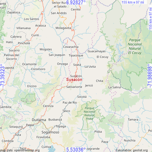
Susacón GPS coordinates[2]
6° 13' 47.208" North, 72° 41' 24.36" West
| Map corner | latitude | longitude |
|---|---|---|
| Upper-left | 6.92827°, | -73.39323° |
| Center: | 6.22978°, | -72.6901° |
| Lower-right: | 5.53036°, | -71.98698° |
| Map W x H: | 155.4×155.4 km | = 96.6×96.6mi |
| max Lat: | 13.38166° ⇑36.5% North |
| Susacón: | 6.22978° |
| min Lat: | ⇓63.5% South -4.21528° |
| min Long | Susacón | max Long |
| -81.70636° | -72.6901° | -67.06996° |
| W 93%⇐ | ⇒7% E |
Elevation
Elevation of Susacón is 2485 m = 8153 ft, and this is 1335.7 m = 4382 ft above average elevation for this country.
| Max E: |
3342 m = 10965 ft | 11.7% |
| Susacón | 2485 m 8153 ft | |
| Avg. | 1149.3 m = 3771 ft | |
Min E: |
1 m = 3 ft | 88.3% |
See also: Colombia elevation on elevation.city.
Geographical zone
Susacón is located in North Torrid zone (between Equator and Tropic of Cancer). Distance of Equator is 692.7 km =430.4 mi to South.| Distance of | km | miles | from Susacón |
|---|---|---|---|
| North Pole | 9314.4 | 5787.7 | to North |
| Arctic Circle | 6708.5 | 4168.5 | to North |
| Tropic Cancer | 1913.2 | 1188.8 | to North |
| Equator | 692.7 | 430.4 | to South |


Nearby cities:
15 places around Susacón: (largest is in red/bold)
• Boavita
16.1 km =10 mi,  46°
46°
• Chita
24.1 km =15 mi,  100°
100°
• Jericó
16.2 km =10.1 mi,  125°
125°
• La Uvita
17.3 km =10.7 mi, 54°
• Onzaga
19 km =11.8 mi,  312°
312°
• Paz de Río
28.1 km =17.5 mi,  193°
193°
• San Mateo
24.4 km =15.2 mi,  38°
38°
• Sativanorte
11.1 km =6.9 mi, 190°
• Sativasur
16 km =9.9 mi, 193°
• Soatá
11.6 km =7.2 mi,  3°
3°
• Socha
25.8 km =16 mi,  180°
180°
• Socha Viejo
27.7 km =17.2 mi, 185°
• Socotá
21.9 km =13.6 mi,  163°
163°
• Tipacoque
21.2 km =13.2 mi,  359°
359°
• Tutazá
28.6 km =17.8 mi,  219°
219°
Sources, notices
• [Note1] Compared only with cities in Colombia existing in our database
• [Src1] Map data: © OpenStreetMap contributors (CC-BY-SA)
• [Src2] Other city data from geonames.org with taken over terms of usage.
• [Src3] Geographical zone / Annual Mean Temperature by Robert A. Rohde @ Wikipedia
