El Cocuy geodata
El Cocuy (Boyacá) is a seat of a second-order administrative division; located in Colombia in America/Bogota (GMT-5) time zone. With population of 2,706 people, there are 715 cities with bigger population in this country. Compared to other cities in Colombia, 66.6% of cities are located further ↓South; 96.5% of cities are located further ←West and 94.4% of cities have lower elevation than El Cocuy. Note1


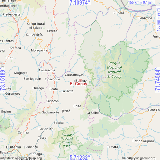
El Cocuy GPS coordinates[2]
6° 24' 41.436" North, 72° 26' 55.536" West
| Map corner | latitude | longitude |
|---|---|---|
| Upper-left | 7.10974°, | -73.15189° |
| Center: | 6.41151°, | -72.44876° |
| Lower-right: | 5.71232°, | -71.74564° |
| Map W x H: | 155.4×155.4 km | = 96.6×96.6mi |
| max Lat: | 13.38166° ⇑33.4% North |
| El Cocuy: | 6.41151° |
| min Lat: | ⇓66.6% South -4.21528° |
| min Long | El Cocuy | max Long |
| -81.70636° | -72.44876° | -67.06996° |
| W 96.5%⇐ | ⇒3.5% E |
Elevation
Elevation of El Cocuy is 2646 m = 8681 ft, and this is 1496.7 m = 4910 ft above average elevation for this country.
| Max E: |
3342 m = 10965 ft | 5.6% |
| El Cocuy | 2646 m 8681 ft | |
| Avg. | 1149.3 m = 3771 ft | |
Min E: |
1 m = 3 ft | 94.4% |
See also: Colombia elevation on elevation.city.
Geographical zone
El Cocuy is located in North Torrid zone (between Equator and Tropic of Cancer). Distance of Equator is 712.9 km =443 mi to South.| Distance of | km | miles | from El Cocuy |
|---|---|---|---|
| North Pole | 9294.2 | 5775.1 | to North |
| Arctic Circle | 6688.3 | 4155.9 | to North |
| Tropic Cancer | 1893 | 1176.3 | to North |
| Equator | 712.9 | 443 | to South |


Nearby cities:
15 places around El Cocuy: (largest is in red/bold)
• Boavita
17.6 km =10.9 mi,  239°
239°
• Capitanejo
30.3 km =18.8 mi,  295°
295°
• Carcasí
31 km =19.3 mi,  320°
320°
• Chiscas
17.2 km =10.7 mi,  339°
339°
• Chita
24.8 km =15.4 mi,  186°
186°
• El Espino
9.6 km =6 mi,  325°
325°
• Guacamayas
8.4 km =5.2 mi,  312°
312°
• Güicán
7 km =4.3 mi,  31°
31°
• La Uvita
16.2 km =10.1 mi,  231°
231°
• Macaravita
19.1 km =11.9 mi, 303°
• Panqueba
4.1 km =2.5 mi, 337°
• San Mateo
11.6 km =7.2 mi,  264°
264°
• San Miguel
28.4 km =17.6 mi, 309°
• Soatá
27.3 km =17 mi,  251°
251°
• Tipacoque
26.9 km =16.7 mi,  272°
272°
Sources, notices
• [Note1] Compared only with cities in Colombia existing in our database
• [Src1] Map data: © OpenStreetMap contributors (CC-BY-SA)
• [Src2] Other city data from geonames.org with taken over terms of usage.
• [Src3] Geographical zone / Annual Mean Temperature by Robert A. Rohde @ Wikipedia
