Soatá geodata
Soatá (Boyacá) is a seat of a second-order administrative division; located in Colombia in America/Bogota (GMT-5) time zone. With population of 10,945 people, there are 281 cities with bigger population in this country. Compared to other cities in Colombia, 65.4% of cities are located further ↓South; 93.1% of cities are located further ←West and 78.4% of cities have lower elevation than Soatá. Note1


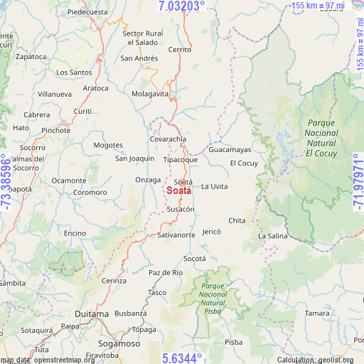
Soatá GPS coordinates[2]
6° 20' 1.284" North, 72° 40' 58.188" West
| Map corner | latitude | longitude |
|---|---|---|
| Upper-left | 7.03203°, | -73.38596° |
| Center: | 6.33369°, | -72.68283° |
| Lower-right: | 5.6344°, | -71.97971° |
| Map W x H: | 155.4×155.4 km | = 96.6×96.6mi |
| max Lat: | 13.38166° ⇑34.6% North |
| Soatá: | 6.33369° |
| min Lat: | ⇓65.4% South -4.21528° |
| min Long | Soatá | max Long |
| -81.70636° | -72.68283° | -67.06996° |
| W 93.1%⇐ | ⇒6.9% E |
Elevation
Elevation of Soatá is 1979 m = 6493 ft, and this is 829.7 m = 2722 ft above average elevation for this country.
| Max E: |
3342 m = 10965 ft | 21.6% |
| Soatá | 1979 m 6493 ft | |
| Avg. | 1149.3 m = 3771 ft | |
Min E: |
1 m = 3 ft | 78.4% |
See also: Colombia elevation on elevation.city.
Geographical zone
Soatá is located in North Torrid zone (between Equator and Tropic of Cancer). Distance of Equator is 704.2 km =437.6 mi to South.| Distance of | km | miles | from Soatá |
|---|---|---|---|
| North Pole | 9302.8 | 5780.5 | to North |
| Arctic Circle | 6696.9 | 4161.3 | to North |
| Tropic Cancer | 1901.7 | 1181.7 | to North |
| Equator | 704.2 | 437.6 | to South |


Nearby cities:
15 places around Soatá: (largest is in red/bold)
• Boavita
10.8 km =6.7 mi,  91°
91°
• Capitanejo
21.7 km =13.5 mi,  356°
356°
• Covarachía
19.9 km =12.4 mi,  343°
343°
• El Espino
26.4 km =16.4 mi,  51°
51°
• Guacamayas
24.3 km =15.1 mi, 53°
• Jericó
24.3 km =15.1 mi,  149°
149°
• La Uvita
13.3 km =8.3 mi,  96°
96°
• Macaravita
21.5 km =13.4 mi,  27°
27°
• Onzaga
14.9 km =9.3 mi,  274°
274°
• San Joaquín
23.1 km =14.4 mi,  297°
297°
• San Mateo
16.2 km =10.1 mi,  62°
62°
• San Miguel
27.2 km =16.9 mi,  8°
8°
• Sativanorte
22.7 km =14.1 mi,  187°
187°
• Susacón
11.6 km =7.2 mi,  183°
183°
• Tipacoque
9.7 km =6 mi,  354°
354°
Sources, notices
• [Note1] Compared only with cities in Colombia existing in our database
• [Src1] Map data: © OpenStreetMap contributors (CC-BY-SA)
• [Src2] Other city data from geonames.org with taken over terms of usage.
• [Src3] Geographical zone / Annual Mean Temperature by Robert A. Rohde @ Wikipedia
