Monterrey geodata
Monterrey (Casanare) is a seat of a second-order administrative division; located in Colombia in America/Bogota (GMT-5) time zone. With population of 7,759 people, there are 377 cities with bigger population in this country. Compared to other cities in Colombia, 64.6% of cities are located further ↑North; 88.6% of cities are located further ←West and 63.8% of cities have higher elevation than Monterrey. Note1


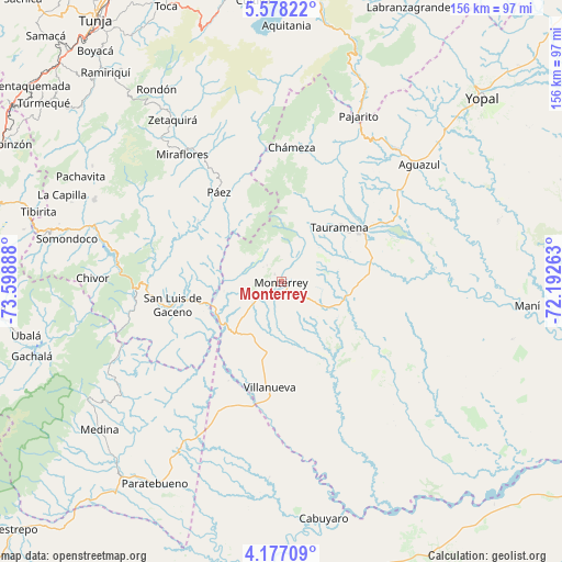
Monterrey GPS coordinates[2]
4° 52' 40.872" North, 72° 53' 44.7" West
| Map corner | latitude | longitude |
|---|---|---|
| Upper-left | 5.57822°, | -73.59888° |
| Center: | 4.87802°, | -72.89575° |
| Lower-right: | 4.17709°, | -72.19263° |
| Map W x H: | 155.8×155.8 km | = 96.8×96.8mi |
| max Lat: | 13.38166° ⇑64.6% North |
| Monterrey: | 4.87802° |
| min Lat: | ⇓35.4% South -4.21528° |
| min Long | Monterrey | max Long |
| -81.70636° | -72.89575° | -67.06996° |
| W 88.6%⇐ | ⇒11.4% E |
Elevation
Elevation of Monterrey is 493 m = 1617 ft, and this is 656.3 m = 2153 ft below average elevation for this country.
| Max E: |
3342 m = 10965 ft | 63.8% |
| Avg. | 1149.3 m = 3771 ft | |
| Monterrey | 493 m = 1617 ft | |
Min E: |
1 m = 3 ft | 36.2% |
See also: Colombia elevation on elevation.city.
Geographical zone
Monterrey is located in North Torrid zone (between Equator and Tropic of Cancer). Distance of Equator is 542.4 km =337 mi to South.| Distance of | km | miles | from Monterrey |
|---|---|---|---|
| North Pole | 9464.7 | 5881.1 | to North |
| Arctic Circle | 6858.8 | 4261.9 | to North |
| Tropic Cancer | 2063.5 | 1282.2 | to North |
| Equator | 542.4 | 337 | to South |


Nearby cities:
15 places around Monterrey: (largest is in red/bold)
• Barranca de Upía
35.2 km =21.9 mi,  192°
192°
• Berbeo
46.4 km =28.8 mi,  326°
326°
• Campohermoso
28.6 km =17.8 mi,  306°
306°
• Chámeza
37.5 km =23.3 mi,  4°
4°
• Macanal
48.1 km =29.9 mi,  282°
282°
• Miraflores
44.9 km =27.9 mi,  322°
322°
• Páez
30.2 km =18.8 mi, 325°
• Recetor
41.8 km =26 mi,  20°
20°
• Sabanalarga
16.2 km =10.1 mi,  260°
260°
• San Eduardo
43.4 km =27 mi, 332°
• San Luis de Gaceno
30.9 km =19.2 mi, 258°
• Santa María
40.7 km =25.3 mi,  267°
267°
• Tauramena
22.7 km =14.1 mi,  46°
46°
• Ubalá
42.3 km =26.3 mi,  110°
110°
• Villanueva
29.8 km =18.5 mi, 186°
Sources, notices
• [Note1] Compared only with cities in Colombia existing in our database
• [Src1] Map data: © OpenStreetMap contributors (CC-BY-SA)
• [Src2] Other city data from geonames.org with taken over terms of usage.
• [Src3] Geographical zone / Annual Mean Temperature by Robert A. Rohde @ Wikipedia
