Páez geodata
Páez (Boyacá) is a seat of a second-order administrative division; located in Colombia in America/Bogota (GMT-5) time zone. With population of 1,220 people, there are 910 cities with bigger population in this country. Compared to other cities in Colombia, 59.5% of cities are located further ↑North; 85.5% of cities are located further ←West and 55.9% of cities have lower elevation than Páez. Note1


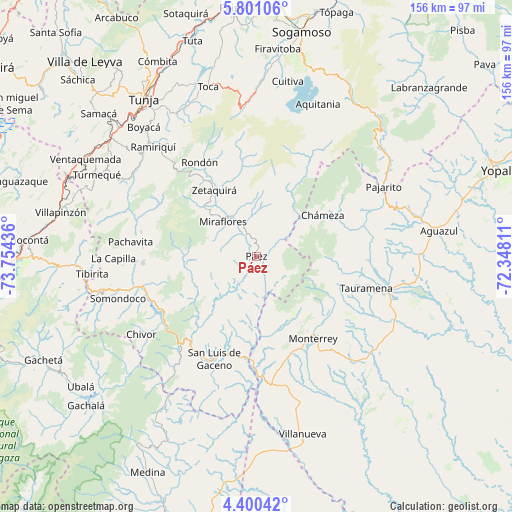
Páez GPS coordinates[2]
5° 6' 4.032" North, 73° 3' 4.428" West
| Map corner | latitude | longitude |
|---|---|---|
| Upper-left | 5.80106°, | -73.75436° |
| Center: | 5.10112°, | -73.05123° |
| Lower-right: | 4.40042°, | -72.34811° |
| Map W x H: | 155.7×155.7 km | = 96.7×96.7mi |
| max Lat: | 13.38166° ⇑59.5% North |
| Páez: | 5.10112° |
| min Lat: | ⇓40.5% South -4.21528° |
| min Long | Páez | max Long |
| -81.70636° | -73.05123° | -67.06996° |
| W 85.5%⇐ | ⇒14.5% E |
Elevation
Elevation of Páez is 1316 m = 4318 ft, and this is 166.7 m = 547 ft above average elevation for this country.
| Max E: |
3342 m = 10965 ft | 44.1% |
| Páez | 1316 m 4318 ft | |
| Avg. | 1149.3 m = 3771 ft | |
Min E: |
1 m = 3 ft | 55.9% |
See also: Colombia elevation on elevation.city.
Geographical zone
Páez is located in North Torrid zone (between Equator and Tropic of Cancer). Distance of Equator is 567.2 km =352.4 mi to South.| Distance of | km | miles | from Páez |
|---|---|---|---|
| North Pole | 9439.9 | 5865.7 | to North |
| Arctic Circle | 6834 | 4246.4 | to North |
| Tropic Cancer | 2038.7 | 1266.8 | to North |
| Equator | 567.2 | 352.4 | to South |


Nearby cities:
15 places around Páez: (largest is in red/bold)
• Berbeo
16.2 km =10.1 mi,  329°
329°
• Campohermoso
9.7 km =6 mi,  216°
216°
• Chámeza
23.7 km =14.7 mi,  58°
58°
• Garagoa
34.6 km =21.5 mi,  266°
266°
• Macanal
33 km =20.5 mi,  244°
244°
• Miraflores
14.8 km =9.2 mi,  315°
315°
• Monterrey
30.2 km =18.8 mi,  145°
145°
• Recetor
35.2 km =21.9 mi,  66°
66°
• Rondón
33.3 km =20.7 mi, 328°
• Sabanalarga
27.5 km =17.1 mi,  177°
177°
• San Eduardo
14 km =8.7 mi,  348°
348°
• San Luis de Gaceno
33.8 km =21 mi,  202°
202°
• Santa María
35.5 km =22.1 mi, 221°
• Tauramena
35 km =21.7 mi,  105°
105°
• Zetaquira
24 km =14.9 mi, 327°
Sources, notices
• [Note1] Compared only with cities in Colombia existing in our database
• [Src1] Map data: © OpenStreetMap contributors (CC-BY-SA)
• [Src2] Other city data from geonames.org with taken over terms of usage.
• [Src3] Geographical zone / Annual Mean Temperature by Robert A. Rohde @ Wikipedia
