Marsella geodata
Marsella (Risaralda) is a seat of a second-order administrative division; located in Colombia in America/Bogota (GMT-5) time zone. With population of 11,158 people, there are 274 cities with bigger population in this country. Compared to other cities in Colombia, 63.6% of cities are located further ↑North; 73.3% of cities are located further →East and 62.8% of cities have lower elevation than Marsella. Note1


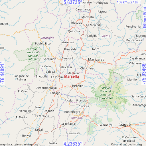
Marsella GPS coordinates[2]
4° 56' 13.992" North, 75° 44' 16.008" West
| Map corner | latitude | longitude |
|---|---|---|
| Upper-left | 5.63735°, | -76.44091° |
| Center: | 4.93722°, | -75.73778° |
| Lower-right: | 4.23635°, | -75.03466° |
| Map W x H: | 155.8×155.8 km | = 96.8×96.8mi |
| max Lat: | 13.38166° ⇑63.6% North |
| Marsella: | 4.93722° |
| min Lat: | ⇓36.4% South -4.21528° |
| min Long | Marsella | max Long |
| -81.70636° | -75.73778° | -67.06996° |
| W 26.7%⇐ | ⇒73.3% E |
Elevation
Elevation of Marsella is 1543 m = 5062 ft, and this is 393.7 m = 1292 ft above average elevation for this country.
| Max E: |
3342 m = 10965 ft | 37.2% |
| Marsella | 1543 m 5062 ft | |
| Avg. | 1149.3 m = 3771 ft | |
Min E: |
1 m = 3 ft | 62.8% |
See also: Colombia elevation on elevation.city.
Geographical zone
Marsella is located in North Torrid zone (between Equator and Tropic of Cancer). Distance of Equator is 549 km =341.1 mi to South.| Distance of | km | miles | from Marsella |
|---|---|---|---|
| North Pole | 9458.1 | 5877 | to North |
| Arctic Circle | 6852.2 | 4257.8 | to North |
| Tropic Cancer | 2057 | 1278.2 | to North |
| Equator | 549 | 341.1 | to South |


Nearby cities:
15 places around Marsella: (largest is in red/bold)
• Balboa
24.5 km =15.2 mi,  273°
273°
• Belalcázar
10.5 km =6.5 mi,  307°
307°
• Cartago
28.7 km =17.8 mi,  222°
222°
• Chinchiná
15.7 km =9.8 mi,  71°
71°
• Dosquebradas
13.4 km =8.3 mi,  144°
144°
• La Virginia
16.6 km =10.3 mi,  255°
255°
• Manizales
28.5 km =17.7 mi,  59°
59°
• Palestina
14.9 km =9.3 mi,  54°
54°
• Pereira
14.5 km =9 mi,  161°
161°
• Risaralda
25.7 km =16 mi,  353°
353°
• San José
17.2 km =10.7 mi,  339°
339°
• Santa Rosa de Cabal
15 km =9.3 mi,  120°
120°
• Ulloa
25.9 km =16.1 mi,  180°
180°
• Villamaría
27.5 km =17.1 mi, 63°
• Viterbo
20.3 km =12.6 mi, 313°
Sources, notices
• [Note1] Compared only with cities in Colombia existing in our database
• [Src1] Map data: © OpenStreetMap contributors (CC-BY-SA)
• [Src2] Other city data from geonames.org with taken over terms of usage.
• [Src3] Geographical zone / Annual Mean Temperature by Robert A. Rohde @ Wikipedia
