La Virginia geodata
La Virginia (Risaralda) is a seat of a second-order administrative division; located in Colombia in America/Bogota (GMT-5) time zone. With population of 33,835 people, there are 110 cities with bigger population in this country. Compared to other cities in Colombia, 64.3% of cities are located further ↑North; 77.7% of cities are located further →East and 57.8% of cities have higher elevation than La Virginia. Note1


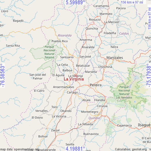
La Virginia GPS coordinates[2]
4° 53' 58.992" North, 75° 52' 57" West
| Map corner | latitude | longitude |
|---|---|---|
| Upper-left | 5.59989°, | -76.58563° |
| Center: | 4.89972°, | -75.8825° |
| Lower-right: | 4.19881°, | -75.17938° |
| Map W x H: | 155.8×155.8 km | = 96.8×96.8mi |
| max Lat: | 13.38166° ⇑64.3% North |
| La Virginia: | 4.89972° |
| min Lat: | ⇓35.7% South -4.21528° |
| min Long | La Virginia | max Long |
| -81.70636° | -75.8825° | -67.06996° |
| W 22.3%⇐ | ⇒77.7% E |
Elevation
Elevation of La Virginia is 901 m = 2956 ft, and this is 248.3 m = 815 ft below average elevation for this country.
| Max E: |
3342 m = 10965 ft | 57.8% |
| Avg. | 1149.3 m = 3771 ft | |
| La Virginia | 901 m = 2956 ft | |
Min E: |
1 m = 3 ft | 42.2% |
See also: Colombia elevation on elevation.city.
Geographical zone
La Virginia is located in North Torrid zone (between Equator and Tropic of Cancer). Distance of Equator is 544.8 km =338.5 mi to South.| Distance of | km | miles | from La Virginia |
|---|---|---|---|
| North Pole | 9462.3 | 5879.6 | to North |
| Arctic Circle | 6856.4 | 4260.4 | to North |
| Tropic Cancer | 2061.1 | 1280.7 | to North |
| Equator | 544.8 | 338.5 | to South |


Nearby cities:
15 places around La Virginia: (largest is in red/bold)
• Alcalá
27.4 km =17 mi,  156°
156°
• Ansermanuevo
16.9 km =10.5 mi,  227°
227°
• Apía
23.9 km =14.9 mi,  343°
343°
• Balboa
10.1 km =6.3 mi,  303°
303°
• Belalcázar
13.1 km =8.1 mi,  36°
36°
• Cartago
17.4 km =10.8 mi,  190°
190°
• Dosquebradas
24.8 km =15.4 mi,  105°
105°
• El Águila
17.5 km =10.9 mi,  274°
274°
• La Celia
17.7 km =11 mi,  310°
310°
• Marsella
16.6 km =10.3 mi,  75°
75°
• Pereira
22.8 km =14.2 mi, 114°
• San José
22.7 km =14.1 mi,  26°
26°
• Santuario
21.4 km =13.3 mi,  334°
334°
• Ulloa
26.8 km =16.7 mi,  144°
144°
• Viterbo
18.1 km =11.2 mi,  3°
3°
Sources, notices
• [Note1] Compared only with cities in Colombia existing in our database
• [Src1] Map data: © OpenStreetMap contributors (CC-BY-SA)
• [Src2] Other city data from geonames.org with taken over terms of usage.
• [Src3] Geographical zone / Annual Mean Temperature by Robert A. Rohde @ Wikipedia
