Palestina geodata
Palestina (Caldas) is a seat of a second-order administrative division; located in Colombia in America/Bogota (GMT-5) time zone. With population of 7,865 people, there are 376 cities with bigger population in this country. Compared to other cities in Colombia, 61.8% of cities are located further ↑North; 70% of cities are located further →East and 61.8% of cities have lower elevation than Palestina. Note1


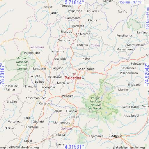
Palestina GPS coordinates[2]
5° 0' 57.96" North, 75° 37' 42.744" West
| Map corner | latitude | longitude |
|---|---|---|
| Upper-left | 5.71614°, | -76.33167° |
| Center: | 5.0161°, | -75.62854° |
| Lower-right: | 4.31531°, | -74.92542° |
| Map W x H: | 155.8×155.8 km | = 96.8×96.8mi |
| max Lat: | 13.38166° ⇑61.8% North |
| Palestina: | 5.0161° |
| min Lat: | ⇓38.2% South -4.21528° |
| min Long | Palestina | max Long |
| -81.70636° | -75.62854° | -67.06996° |
| W 30%⇐ | ⇒70% E |
Elevation
Elevation of Palestina is 1527 m = 5010 ft, and this is 377.7 m = 1239 ft above average elevation for this country.
| Max E: |
3342 m = 10965 ft | 38.2% |
| Palestina | 1527 m 5010 ft | |
| Avg. | 1149.3 m = 3771 ft | |
Min E: |
1 m = 3 ft | 61.8% |
See also: Colombia elevation on elevation.city.
Geographical zone
Palestina is located in North Torrid zone (between Equator and Tropic of Cancer). Distance of Equator is 557.7 km =346.5 mi to South.| Distance of | km | miles | from Palestina |
|---|---|---|---|
| North Pole | 9449.3 | 5871.5 | to North |
| Arctic Circle | 6843.4 | 4252.3 | to North |
| Tropic Cancer | 2048.2 | 1272.7 | to North |
| Equator | 557.7 | 346.5 | to South |


Nearby cities:
15 places around Palestina: (largest is in red/bold)
• Anserma
29.8 km =18.5 mi,  324°
324°
• Belalcázar
20.5 km =12.7 mi,  263°
263°
• Chinchiná
4.6 km =2.9 mi,  143°
143°
• Dosquebradas
20.1 km =12.5 mi,  192°
192°
• Filadelfia
32 km =19.9 mi,  13°
13°
• La Virginia
31 km =19.3 mi,  245°
245°
• Manizales
13.6 km =8.5 mi,  64°
64°
• Marsella
14.9 km =9.3 mi,  234°
234°
• Neira
20.6 km =12.8 mi,  35°
35°
• Pereira
23.8 km =14.8 mi,  198°
198°
• Risaralda
22.6 km =14 mi, 317°
• San José
19.4 km =12.1 mi,  292°
292°
• Santa Rosa de Cabal
16.5 km =10.3 mi,  177°
177°
• Villamaría
13 km =8.1 mi,  75°
75°
• Viterbo
27.4 km =17 mi,  280°
280°
Sources, notices
• [Note1] Compared only with cities in Colombia existing in our database
• [Src1] Map data: © OpenStreetMap contributors (CC-BY-SA)
• [Src2] Other city data from geonames.org with taken over terms of usage.
• [Src3] Geographical zone / Annual Mean Temperature by Robert A. Rohde @ Wikipedia
