Chinchiná geodata
Chinchiná (Caldas) is a seat of a second-order administrative division; located in Colombia in America/Bogota (GMT-5) time zone. With population of 68,512 people, there are 58 cities with bigger population in this country. Compared to other cities in Colombia, 62.6% of cities are located further ↑North; 68.9% of cities are located further →East and 57.4% of cities have lower elevation than Chinchiná. Note1


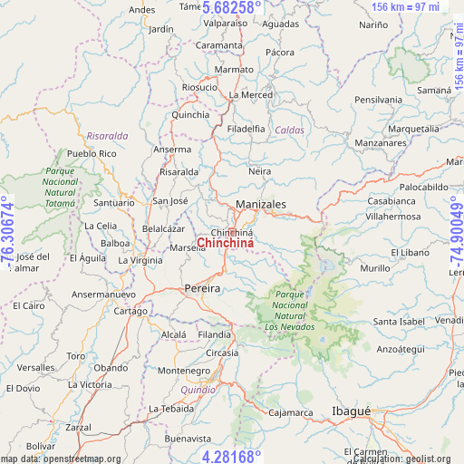
Chinchiná GPS coordinates[2]
4° 58' 57" North, 75° 36' 12.996" West
| Map corner | latitude | longitude |
|---|---|---|
| Upper-left | 5.68258°, | -76.30674° |
| Center: | 4.9825°, | -75.60361° |
| Lower-right: | 4.28168°, | -74.90049° |
| Map W x H: | 155.8×155.8 km | = 96.8×96.8mi |
| max Lat: | 13.38166° ⇑62.6% North |
| Chinchiná: | 4.9825° |
| min Lat: | ⇓37.4% South -4.21528° |
| min Long | Chinchiná | max Long |
| -81.70636° | -75.60361° | -67.06996° |
| W 31.1%⇐ | ⇒68.9% E |
Elevation
Elevation of Chinchiná is 1382 m = 4534 ft, and this is 232.7 m = 763 ft above average elevation for this country.
| Max E: |
3342 m = 10965 ft | 42.6% |
| Chinchiná | 1382 m 4534 ft | |
| Avg. | 1149.3 m = 3771 ft | |
Min E: |
1 m = 3 ft | 57.4% |
See also: Chinchiná elevation on elevation.city.
Geographical zone
Chinchiná is located in North Torrid zone (between Equator and Tropic of Cancer). Distance of Equator is 554 km =344.2 mi to South.| Distance of | km | miles | from Chinchiná |
|---|---|---|---|
| North Pole | 9453.1 | 5873.9 | to North |
| Arctic Circle | 6847.2 | 4254.7 | to North |
| Tropic Cancer | 2051.9 | 1275 | to North |
| Equator | 554 | 344.2 | to South |


Nearby cities:
15 places around Chinchiná: (largest is in red/bold)
• Aranzazu
34.5 km =21.4 mi,  21°
21°
• Belalcázar
23.2 km =14.4 mi,  273°
273°
• Dosquebradas
17.4 km =10.8 mi,  203°
203°
• La Virginia
32.2 km =20 mi,  253°
253°
• Manizales
13.5 km =8.4 mi,  44°
44°
• Marsella
15.7 km =9.8 mi, 251°
• Neira
22.5 km =14 mi, 24°
• Palestina
4.6 km =2.9 mi,  323°
323°
• Pereira
21.4 km =13.3 mi,  208°
208°
• Risaralda
27.2 km =16.9 mi, 318°
• San José
23.5 km =14.6 mi,  298°
298°
• Santa Rosa de Cabal
12.9 km =8 mi,  188°
188°
• Ulloa
34.4 km =21.4 mi, 206°
• Villamaría
12.1 km =7.5 mi,  54°
54°
• Viterbo
31 km =19.3 mi,  286°
286°
Sources, notices
• [Note1] Compared only with cities in Colombia existing in our database
• [Src1] Map data: © OpenStreetMap contributors (CC-BY-SA)
• [Src2] Other city data from geonames.org with taken over terms of usage.
• [Src3] Geographical zone / Annual Mean Temperature by Robert A. Rohde @ Wikipedia
