Salento geodata
Salento (Quindío) is a seat of a second-order administrative division; located in Colombia in America/Bogota (GMT-5) time zone. With population of 4,135 people, there are 572 cities with bigger population in this country. Compared to other cities in Colombia, 69.1% of cities are located further ↑North; 68.3% of cities are located further →East and 78.9% of cities have lower elevation than Salento. Note1


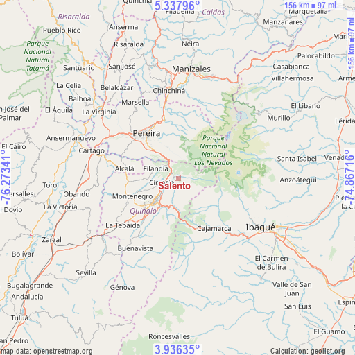
Salento GPS coordinates[2]
4° 38' 15" North, 75° 34' 13.008" West
| Map corner | latitude | longitude |
|---|---|---|
| Upper-left | 5.33796°, | -76.27341° |
| Center: | 4.6375°, | -75.57028° |
| Lower-right: | 3.93635°, | -74.86716° |
| Map W x H: | 155.8×155.8 km | = 96.8×96.8mi |
| max Lat: | 13.38166° ⇑69.1% North |
| Salento: | 4.6375° |
| min Lat: | ⇓30.9% South -4.21528° |
| min Long | Salento | max Long |
| -81.70636° | -75.57028° | -67.06996° |
| W 31.7%⇐ | ⇒68.3% E |
Elevation
Elevation of Salento is 1995 m = 6545 ft, and this is 845.7 m = 2775 ft above average elevation for this country.
| Max E: |
3342 m = 10965 ft | 21.1% |
| Salento | 1995 m 6545 ft | |
| Avg. | 1149.3 m = 3771 ft | |
Min E: |
1 m = 3 ft | 78.9% |
See also: Colombia elevation on elevation.city.
Geographical zone
Salento is located in North Torrid zone (between Equator and Tropic of Cancer). Distance of Equator is 515.6 km =320.4 mi to South.| Distance of | km | miles | from Salento |
|---|---|---|---|
| North Pole | 9491.4 | 5897.7 | to North |
| Arctic Circle | 6885.5 | 4278.5 | to North |
| Tropic Cancer | 2090.3 | 1298.9 | to North |
| Equator | 515.6 | 320.4 | to South |


Nearby cities:
15 places around Salento: (largest is in red/bold)
• Alcalá
23.9 km =14.9 mi,  279°
279°
• Anaime
30.2 km =18.8 mi,  152°
152°
• Armenia
16.8 km =10.4 mi,  226°
226°
• Cajamarca
26.8 km =16.7 mi,  144°
144°
• Calarcá
14.3 km =8.9 mi,  213°
213°
• Circasia
7.6 km =4.7 mi,  254°
254°
• Córdoba
30.3 km =18.8 mi, 205°
• Dosquebradas
24.9 km =15.5 mi,  334°
334°
• Filandia
10.6 km =6.6 mi,  292°
292°
• La Tebaida
31.7 km =19.7 mi, 229°
• Montenegro
21.5 km =13.4 mi, 248°
• Pereira
24 km =14.9 mi,  324°
324°
• Quimbaya
21.4 km =13.3 mi,  265°
265°
• Santa Rosa de Cabal
26.3 km =16.3 mi,  347°
347°
• Ulloa
20.3 km =12.6 mi, 291°
Sources, notices
• [Note1] Compared only with cities in Colombia existing in our database
• [Src1] Map data: © OpenStreetMap contributors (CC-BY-SA)
• [Src2] Other city data from geonames.org with taken over terms of usage.
• [Src3] Geographical zone / Annual Mean Temperature by Robert A. Rohde @ Wikipedia
