Montenegro geodata
Montenegro (Quindío) is a seat of a second-order administrative division; located in Colombia in America/Bogota (GMT-5) time zone. With population of 36,499 people, there are 106 cities with bigger population in this country. Compared to other cities in Colombia, 70.3% of cities are located further ↑North; 73.7% of cities are located further →East and 55.1% of cities have lower elevation than Montenegro. Note1


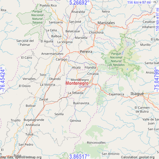
Montenegro GPS coordinates[2]
4° 33' 59.004" North, 75° 45' 3.996" West
| Map corner | latitude | longitude |
|---|---|---|
| Upper-left | 5.26692°, | -76.45424° |
| Center: | 4.56639°, | -75.75111° |
| Lower-right: | 3.86517°, | -75.04799° |
| Map W x H: | 155.9×155.9 km | = 96.9×96.9mi |
| max Lat: | 13.38166° ⇑70.3% North |
| Montenegro: | 4.56639° |
| min Lat: | ⇓29.7% South -4.21528° |
| min Long | Montenegro | max Long |
| -81.70636° | -75.75111° | -67.06996° |
| W 26.3%⇐ | ⇒73.7% E |
Elevation
Elevation of Montenegro is 1297 m = 4255 ft, and this is 147.7 m = 485 ft above average elevation for this country.
| Max E: |
3342 m = 10965 ft | 44.9% |
| Montenegro | 1297 m 4255 ft | |
| Avg. | 1149.3 m = 3771 ft | |
Min E: |
1 m = 3 ft | 55.1% |
See also: Colombia elevation on elevation.city.
Geographical zone
Montenegro is located in North Torrid zone (between Equator and Tropic of Cancer). Distance of Equator is 507.7 km =315.5 mi to South.| Distance of | km | miles | from Montenegro |
|---|---|---|---|
| North Pole | 9499.3 | 5902.6 | to North |
| Arctic Circle | 6893.4 | 4283.4 | to North |
| Tropic Cancer | 2098.2 | 1303.8 | to North |
| Equator | 507.7 | 315.5 | to South |


Nearby cities:
15 places around Montenegro: (largest is in red/bold)
• Alcalá
12.5 km =7.8 mi,  343°
343°
• Armenia
8.6 km =5.3 mi,  114°
114°
• Buenavista
23 km =14.3 mi,  176°
176°
• Caicedonia
27.3 km =17 mi,  197°
197°
• Calarcá
12.9 km =8 mi, 108°
• Cartago
26.8 km =16.7 mi,  318°
318°
• Circasia
14 km =8.7 mi,  65°
65°
• Córdoba
20.7 km =12.9 mi,  159°
159°
• Filandia
15.8 km =9.8 mi,  40°
40°
• La Tebaida
13.3 km =8.3 mi, 197°
• Obando
24.7 km =15.3 mi,  272°
272°
• Pijao
26.4 km =16.4 mi,  168°
168°
• Quimbaya
6.4 km =4 mi,  348°
348°
• Salento
21.5 km =13.4 mi, 68°
• Ulloa
15.4 km =9.6 mi,  4°
4°
Sources, notices
• [Note1] Compared only with cities in Colombia existing in our database
• [Src1] Map data: © OpenStreetMap contributors (CC-BY-SA)
• [Src2] Other city data from geonames.org with taken over terms of usage.
• [Src3] Geographical zone / Annual Mean Temperature by Robert A. Rohde @ Wikipedia
