Pereira geodata
Pereira (Risaralda) is a seat of a first-order administrative division; located in Colombia in America/Bogota (GMT-5) time zone. With population of 440,118 people, there are 7 cities with bigger population in this country. Compared to other cities in Colombia, 66.4% of cities are located further ↑North; 71.9% of cities are located further →East and 58.2% of cities have lower elevation than Pereira. Note1


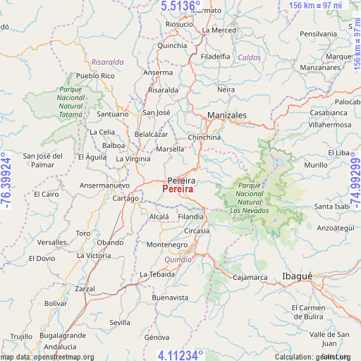
Pereira GPS coordinates[2]
4° 48' 47.988" North, 75° 41' 45.996" West
| Map corner | latitude | longitude |
|---|---|---|
| Upper-left | 5.5136°, | -76.39924° |
| Center: | 4.81333°, | -75.69611° |
| Lower-right: | 4.11234°, | -74.99299° |
| Map W x H: | 155.8×155.8 km | = 96.8×96.8mi |
| max Lat: | 13.38166° ⇑66.4% North |
| Pereira: | 4.81333° |
| min Lat: | ⇓33.6% South -4.21528° |
| min Long | Pereira | max Long |
| -81.70636° | -75.69611° | -67.06996° |
| W 28.1%⇐ | ⇒71.9% E |
Elevation
Elevation of Pereira is 1414 m = 4639 ft, and this is 264.7 m = 868 ft above average elevation for this country.
| Max E: |
3342 m = 10965 ft | 41.8% |
| Pereira | 1414 m 4639 ft | |
| Avg. | 1149.3 m = 3771 ft | |
Min E: |
1 m = 3 ft | 58.2% |
See also: Pereira elevation on elevation.city.
Geographical zone
Pereira is located in North Torrid zone (between Equator and Tropic of Cancer). Distance of Equator is 535.2 km =332.6 mi to South.| Distance of | km | miles | from Pereira |
|---|---|---|---|
| North Pole | 9471.9 | 5885.6 | to North |
| Arctic Circle | 6866 | 4266.3 | to North |
| Tropic Cancer | 2070.7 | 1286.7 | to North |
| Equator | 535.2 | 332.6 | to South |


Nearby cities:
15 places around Pereira: (largest is in red/bold)
• Alcalá
18.1 km =11.2 mi,  211°
211°
• Belalcázar
24 km =14.9 mi,  327°
327°
• Cartago
25 km =15.5 mi,  252°
252°
• Chinchiná
21.4 km =13.3 mi,  28°
28°
• Circasia
22.6 km =14 mi,  162°
162°
• Dosquebradas
4.3 km =2.7 mi,  48°
48°
• Filandia
16 km =9.9 mi, 164°
• La Virginia
22.8 km =14.2 mi,  294°
294°
• Marsella
14.5 km =9 mi,  341°
341°
• Montenegro
28.1 km =17.5 mi,  192°
192°
• Palestina
23.8 km =14.8 mi,  18°
18°
• Quimbaya
22.4 km =13.9 mi,  199°
199°
• Salento
24 km =14.9 mi,  144°
144°
• Santa Rosa de Cabal
10.3 km =6.4 mi, 53°
• Ulloa
13.1 km =8.1 mi, 202°
Sources, notices
• [Note1] Compared only with cities in Colombia existing in our database
• [Src1] Map data: © OpenStreetMap contributors (CC-BY-SA)
• [Src2] Other city data from geonames.org with taken over terms of usage.
• [Src3] Geographical zone / Annual Mean Temperature by Robert A. Rohde @ Wikipedia
