Miraflores geodata
Miraflores (Boyacá) is a seat of a second-order administrative division; located in Colombia in America/Bogota (GMT-5) time zone. With population of 2,766 people, there are 704 cities with bigger population in this country. Compared to other cities in Colombia, 57.7% of cities are located further ↑North; 84% of cities are located further ←West and 61.5% of cities have lower elevation than Miraflores. Note1


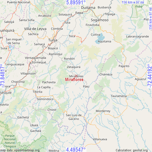
Miraflores GPS coordinates[2]
5° 11' 45.888" North, 73° 8' 42.144" West
| Map corner | latitude | longitude |
|---|---|---|
| Upper-left | 5.89591°, | -73.84817° |
| Center: | 5.19608°, | -73.14504° |
| Lower-right: | 4.49547°, | -72.44192° |
| Map W x H: | 155.7×155.7 km | = 96.7×96.7mi |
| max Lat: | 13.38166° ⇑57.7% North |
| Miraflores: | 5.19608° |
| min Lat: | ⇓42.3% South -4.21528° |
| min Long | Miraflores | max Long |
| -81.70636° | -73.14504° | -67.06996° |
| W 84%⇐ | ⇒16% E |
Elevation
Elevation of Miraflores is 1518 m = 4980 ft, and this is 368.7 m = 1210 ft above average elevation for this country.
| Max E: |
3342 m = 10965 ft | 38.5% |
| Miraflores | 1518 m 4980 ft | |
| Avg. | 1149.3 m = 3771 ft | |
Min E: |
1 m = 3 ft | 61.5% |
See also: Colombia elevation on elevation.city.
Geographical zone
Miraflores is located in North Torrid zone (between Equator and Tropic of Cancer). Distance of Equator is 577.7 km =359 mi to South.| Distance of | km | miles | from Miraflores |
|---|---|---|---|
| North Pole | 9429.3 | 5859.1 | to North |
| Arctic Circle | 6823.4 | 4239.9 | to North |
| Tropic Cancer | 2028.2 | 1260.3 | to North |
| Equator | 577.7 | 359 | to South |


Nearby cities:
15 places around Miraflores: (largest is in red/bold)
• Berbeo
4 km =2.5 mi,  31°
31°
• Campohermoso
18.9 km =11.7 mi,  165°
165°
• Chinavita
24.9 km =15.5 mi,  262°
262°
• Chámeza
30.6 km =19 mi,  86°
86°
• Ciénega
28.9 km =18 mi,  324°
324°
• Garagoa
27.3 km =17 mi,  242°
242°
• Macanal
31.5 km =19.6 mi,  217°
217°
• Pachavita
28.6 km =17.8 mi, 257°
• Páez
14.8 km =9.2 mi,  135°
135°
• Ramiriquí
31 km =19.3 mi, 317°
• Rondón
19.2 km =11.9 mi,  338°
338°
• San Eduardo
8.2 km =5.1 mi,  67°
67°
• Tibaná
30.9 km =19.2 mi,  295°
295°
• Viracachá
31.5 km =19.6 mi,  327°
327°
• Zetaquira
9.9 km =6.2 mi, 344°
Sources, notices
• [Note1] Compared only with cities in Colombia existing in our database
• [Src1] Map data: © OpenStreetMap contributors (CC-BY-SA)
• [Src2] Other city data from geonames.org with taken over terms of usage.
• [Src3] Geographical zone / Annual Mean Temperature by Robert A. Rohde @ Wikipedia
