San Eduardo geodata
San Eduardo (Boyacá) is a seat of a second-order administrative division; located in Colombia in America/Bogota (GMT-5) time zone. With population of 524 people, there are 1026 cities with bigger population in this country. Compared to other cities in Colombia, 56.6% of cities are located further ↑North; 85.2% of cities are located further ←West and 67.5% of cities have lower elevation than San Eduardo. Note1


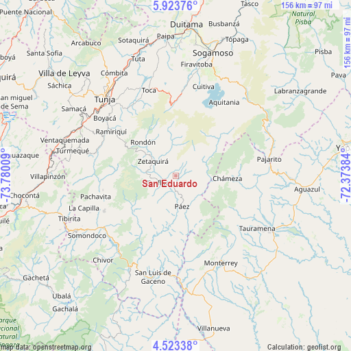
San Eduardo GPS coordinates[2]
5° 13' 26.256" North, 73° 4' 37.056" West
| Map corner | latitude | longitude |
|---|---|---|
| Upper-left | 5.92376°, | -73.78009° |
| Center: | 5.22396°, | -73.07696° |
| Lower-right: | 4.52338°, | -72.37384° |
| Map W x H: | 155.7×155.7 km | = 96.7×96.7mi |
| max Lat: | 13.38166° ⇑56.6% North |
| San Eduardo: | 5.22396° |
| min Lat: | ⇓43.4% South -4.21528° |
| min Long | San Eduardo | max Long |
| -81.70636° | -73.07696° | -67.06996° |
| W 85.2%⇐ | ⇒14.8% E |
Elevation
Elevation of San Eduardo is 1661 m = 5449 ft, and this is 511.7 m = 1679 ft above average elevation for this country.
| Max E: |
3342 m = 10965 ft | 32.5% |
| San Eduardo | 1661 m 5449 ft | |
| Avg. | 1149.3 m = 3771 ft | |
Min E: |
1 m = 3 ft | 67.5% |
See also: Colombia elevation on elevation.city.
Geographical zone
San Eduardo is located in North Torrid zone (between Equator and Tropic of Cancer). Distance of Equator is 580.8 km =360.9 mi to South.| Distance of | km | miles | from San Eduardo |
|---|---|---|---|
| North Pole | 9426.2 | 5857.2 | to North |
| Arctic Circle | 6820.3 | 4237.9 | to North |
| Tropic Cancer | 2025.1 | 1258.3 | to North |
| Equator | 580.8 | 360.9 | to South |


Nearby cities:
15 places around San Eduardo: (largest is in red/bold)
• Berbeo
5.4 km =3.4 mi,  273°
273°
• Campohermoso
21.6 km =13.4 mi,  187°
187°
• Chinavita
32.9 km =20.4 mi,  258°
258°
• Chámeza
23 km =14.3 mi,  92°
92°
• Ciénega
31.8 km =19.8 mi,  310°
310°
• Garagoa
35.4 km =22 mi,  243°
243°
• Jenesano
36.5 km =22.7 mi,  299°
299°
• Miraflores
8.2 km =5.1 mi,  247°
247°
• Pesca
36.4 km =22.6 mi,  4°
4°
• Páez
14 km =8.7 mi,  168°
168°
• Ramiriquí
34.7 km =21.6 mi, 304°
• Recetor
35 km =21.7 mi, 88°
• Rondón
20.8 km =12.9 mi,  315°
315°
• Viracachá
33.9 km =21.1 mi, 314°
• Zetaquira
12.1 km =7.5 mi, 302°
Sources, notices
• [Note1] Compared only with cities in Colombia existing in our database
• [Src1] Map data: © OpenStreetMap contributors (CC-BY-SA)
• [Src2] Other city data from geonames.org with taken over terms of usage.
• [Src3] Geographical zone / Annual Mean Temperature by Robert A. Rohde @ Wikipedia
