Inírida geodata
Inírida (Guainía) is a seat of a first-order administrative division; located in Colombia in America/Bogota (GMT-5) time zone. With population of 7,298 people, there are 395 cities with bigger population in this country. Compared to other cities in Colombia, 79% of cities are located further ↑North; 99.8% of cities are located further ←West and 81.4% of cities have higher elevation than Inírida. Note1


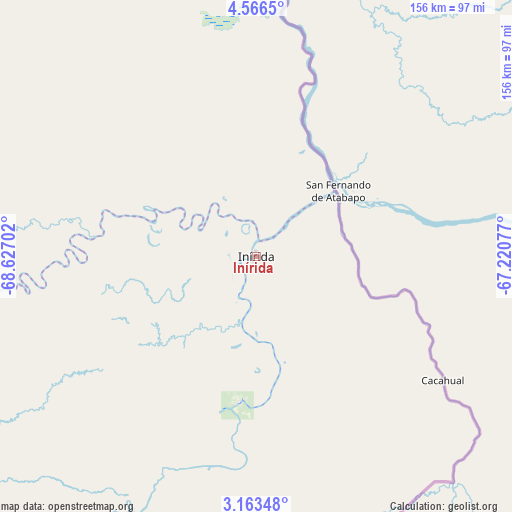
Inírida GPS coordinates[2]
3° 51' 55.008" North, 67° 55' 26.004" West
| Map corner | latitude | longitude |
|---|---|---|
| Upper-left | 4.5665°, | -68.62702° |
| Center: | 3.86528°, | -67.92389° |
| Lower-right: | 3.16348°, | -67.22077° |
| Map W x H: | 156×156 km | = 96.9×96.9mi |
| max Lat: | 13.38166° ⇑79% North |
| Inírida: | 3.86528° |
| min Lat: | ⇓21% South -4.21528° |
| min Long | Inírida | max Long |
| -81.70636° | -67.92389° | -67.06996° |
| W 99.8%⇐ | ⇒0.2% E |
Elevation
Elevation of Inírida is 98 m = 322 ft, and this is 1051.3 m = 3449 ft below average elevation for this country.
| Max E: |
3342 m = 10965 ft | 81.4% |
| Avg. | 1149.3 m = 3771 ft | |
| Inírida | 98 m = 322 ft | |
Min E: |
1 m = 3 ft | 18.6% |
See also: Colombia elevation on elevation.city.
Geographical zone
Inírida is located in North Torrid zone (between Equator and Tropic of Cancer). Distance of Equator is 429.8 km =267.1 mi to South.| Distance of | km | miles | from Inírida |
|---|---|---|---|
| North Pole | 9577.3 | 5951.1 | to North |
| Arctic Circle | 6971.4 | 4331.8 | to North |
| Tropic Cancer | 2176.1 | 1352.2 | to North |
| Equator | 429.8 | 267.1 | to South |


Nearby cities:
9 places around Inírida: (largest is in red/bold)
• Cravo Norte
370.4 km =230.2 mi,  317°
317°
• Cumaribo
217.7 km =135.3 mi,  287°
287°
• La Primavera
329.4 km =204.7 mi,  303°
303°
• Mitú
387.2 km =240.6 mi,  221°
221°
• Orocué
392.4 km =243.8 mi, 285°
• Puerto Carreño
262.9 km =163.4 mi,  10°
10°
• Puerto Rondón
442.5 km =275 mi,  307°
307°
• San Felipe
236.8 km =147.1 mi,  156°
156°
• Santa Rosalia
354.9 km =220.5 mi, 293°
Sources, notices
• [Note1] Compared only with cities in Colombia existing in our database
• [Src1] Map data: © OpenStreetMap contributors (CC-BY-SA)
• [Src2] Other city data from geonames.org with taken over terms of usage.
• [Src3] Geographical zone / Annual Mean Temperature by Robert A. Rohde @ Wikipedia
