Cumaribo geodata
Cumaribo (Vichada) is a seat of a second-order administrative division; located in Colombia in America/Bogota (GMT-5) time zone. With population of 23,990 people, there are 151 cities with bigger population in this country. Compared to other cities in Colombia, 72% of cities are located further ↑North; 99.7% of cities are located further ←West and 76.8% of cities have higher elevation than Cumaribo. Note1


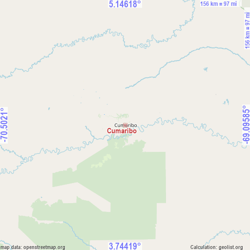
Cumaribo GPS coordinates[2]
4° 26' 43.872" North, 69° 47' 56.292" West
| Map corner | latitude | longitude |
|---|---|---|
| Upper-left | 5.14618°, | -70.5021° |
| Center: | 4.44552°, | -69.79897° |
| Lower-right: | 3.74419°, | -69.09585° |
| Map W x H: | 155.9×155.9 km | = 96.9×96.9mi |
| max Lat: | 13.38166° ⇑72% North |
| Cumaribo: | 4.44552° |
| min Lat: | ⇓28% South -4.21528° |
| min Long | Cumaribo | max Long |
| -81.70636° | -69.79897° | -67.06996° |
| W 99.7%⇐ | ⇒0.3% E |
Elevation
Elevation of Cumaribo is 161 m = 528 ft, and this is 988.3 m = 3242 ft below average elevation for this country.
| Max E: |
3342 m = 10965 ft | 76.8% |
| Avg. | 1149.3 m = 3771 ft | |
| Cumaribo | 161 m = 528 ft | |
Min E: |
1 m = 3 ft | 23.2% |
See also: Colombia elevation on elevation.city.
Geographical zone
Cumaribo is located in North Torrid zone (between Equator and Tropic of Cancer). Distance of Equator is 494.3 km =307.1 mi to South.| Distance of | km | miles | from Cumaribo |
|---|---|---|---|
| North Pole | 9512.8 | 5911 | to North |
| Arctic Circle | 6906.9 | 4291.7 | to North |
| Tropic Cancer | 2111.6 | 1312.1 | to North |
| Equator | 494.3 | 307.1 | to South |


Nearby cities:
15 places around Cumaribo: (largest is in red/bold)
• Cravo Norte
211.2 km =131.2 mi,  347°
347°
• Inírida
217.7 km =135.3 mi,  107°
107°
• La Primavera
134.4 km =83.5 mi,  329°
329°
• Maní
278 km =172.7 mi,  278°
278°
• Municipio Hato Corozal
289 km =179.6 mi,  311°
311°
• Orocué
175 km =108.7 mi, 282°
• Paz de Ariporo
281.4 km =174.9 mi,  304°
304°
• Pore
281.7 km =175 mi, 300°
• Puerto Gaitán
253.5 km =157.5 mi,  266°
266°
• Puerto Rondón
249.7 km =155.2 mi,  324°
324°
• San Luis de Palenque
240 km =149.1 mi, 296°
• Santa Rosalia
140.5 km =87.3 mi, 302°
• Tibacuy
294.8 km =183.2 mi, 267°
• Trinidad
232.5 km =144.5 mi, 297°
• Villanueva
257.6 km =160.1 mi,  291°
291°
Sources, notices
• [Note1] Compared only with cities in Colombia existing in our database
• [Src1] Map data: © OpenStreetMap contributors (CC-BY-SA)
• [Src2] Other city data from geonames.org with taken over terms of usage.
• [Src3] Geographical zone / Annual Mean Temperature by Robert A. Rohde @ Wikipedia
