Puerto Carreño geodata
Puerto Carreño (Vichada) is a seat of a first-order administrative division; located in Colombia in America/Bogota (GMT-5) time zone. With population of 10,216 people, there are 299 cities with bigger population in this country. Compared to other cities in Colombia, 63% of cities are located further ↓South; 99.9% of cities are located further ←West and 86% of cities have higher elevation than Puerto Carreño. Note1


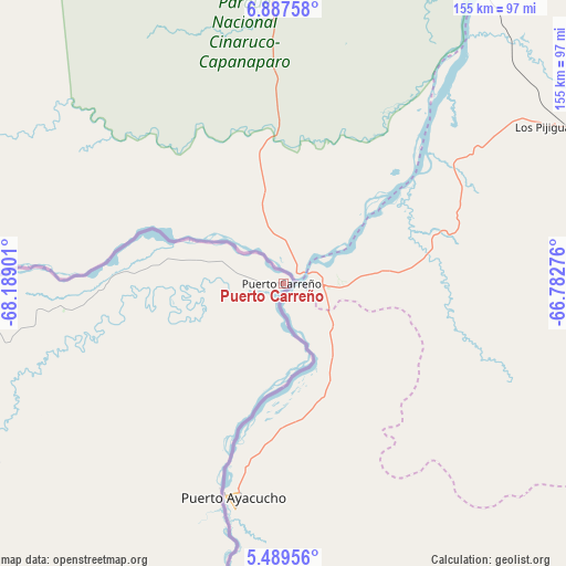
Puerto Carreño GPS coordinates[2]
6° 11' 20.508" North, 67° 29' 9.168" West
| Map corner | latitude | longitude |
|---|---|---|
| Upper-left | 6.88758°, | -68.18901° |
| Center: | 6.18903°, | -67.48588° |
| Lower-right: | 5.48956°, | -66.78276° |
| Map W x H: | 155.4×155.4 km | = 96.6×96.6mi |
| max Lat: | 13.38166° ⇑37% North |
| Puerto Carreño: | 6.18903° |
| min Lat: | ⇓63% South -4.21528° |
| min Long | Puerto Carreño | max Long |
| -81.70636° | -67.48588° | -67.06996° |
| W 99.9%⇐ | ⇒0.099999999999994% E |
Elevation
Elevation of Puerto Carreño is 51 m = 167 ft, and this is 1098.3 m = 3603 ft below average elevation for this country.
| Max E: |
3342 m = 10965 ft | 86% |
| Avg. | 1149.3 m = 3771 ft | |
| Puerto Carreño | 51 m = 167 ft | |
Min E: |
1 m = 3 ft | 14% |
See also: Colombia elevation on elevation.city.
Geographical zone
Puerto Carreño is located in North Torrid zone (between Equator and Tropic of Cancer). Distance of Equator is 688.2 km =427.6 mi to South.| Distance of | km | miles | from Puerto Carreño |
|---|---|---|---|
| North Pole | 9318.9 | 5790.5 | to North |
| Arctic Circle | 6713 | 4171.3 | to North |
| Tropic Cancer | 1917.8 | 1191.7 | to North |
| Equator | 688.2 | 427.6 | to South |


Nearby cities:
7 places around Puerto Carreño: (largest is in red/bold)
• Arauca
375 km =233 mi,  285°
285°
• Cravo Norte
300.7 km =186.8 mi,  272°
272°
• Cumaribo
321.2 km =199.6 mi,  232°
232°
• Inírida
262.9 km =163.4 mi,  190°
190°
• La Primavera
332.5 km =206.6 mi,  256°
256°
• Puerto Rondón
399.6 km =248.3 mi, 271°
• Santa Rosalia
391.6 km =243.3 mi,  252°
252°
Sources, notices
• [Note1] Compared only with cities in Colombia existing in our database
• [Src1] Map data: © OpenStreetMap contributors (CC-BY-SA)
• [Src2] Other city data from geonames.org with taken over terms of usage.
• [Src3] Geographical zone / Annual Mean Temperature by Robert A. Rohde @ Wikipedia
