Arauca geodata
Arauca is a seat of a first-order administrative division; located in Colombia in America/Bogota (GMT-5) time zone. With population of 69,264 people, there are 56 cities with bigger population in this country. Compared to other cities in Colombia, 75.2% of cities are located further ↓South; 99.1% of cities are located further ←West and 79% of cities have higher elevation than Arauca. Note1


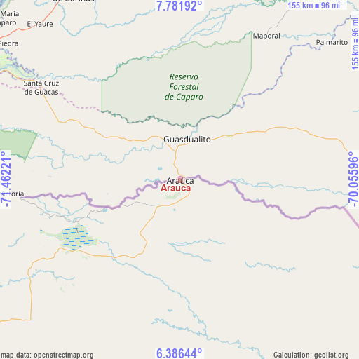
Arauca GPS coordinates[2]
7° 5' 4.956" North, 70° 45' 32.688" West
| Map corner | latitude | longitude |
|---|---|---|
| Upper-left | 7.78192°, | -71.46221° |
| Center: | 7.08471°, | -70.75908° |
| Lower-right: | 6.38644°, | -70.05596° |
| Map W x H: | 155.2×155.2 km | = 96.4×96.4mi |
| max Lat: | 13.38166° ⇑24.8% North |
| Arauca: | 7.08471° |
| min Lat: | ⇓75.2% South -4.21528° |
| min Long | Arauca | max Long |
| -81.70636° | -70.75908° | -67.06996° |
| W 99.1%⇐ | ⇒0.90000000000001% E |
Elevation
Elevation of Arauca is 132 m = 433 ft, and this is 1017.3 m = 3338 ft below average elevation for this country.
| Max E: |
3342 m = 10965 ft | 79% |
| Avg. | 1149.3 m = 3771 ft | |
| Arauca | 132 m = 433 ft | |
Min E: |
1 m = 3 ft | 21% |
See also: Arauca elevation on elevation.city.
Geographical zone
Arauca is located in North Torrid zone (between Equator and Tropic of Cancer). Distance of Equator is 787.7 km =489.5 mi to South.| Distance of | km | miles | from Arauca |
|---|---|---|---|
| North Pole | 9219.3 | 5728.6 | to North |
| Arctic Circle | 6613.4 | 4109.4 | to North |
| Tropic Cancer | 1818.2 | 1129.8 | to North |
| Equator | 787.7 | 489.5 | to South |


Nearby cities:
15 places around Arauca: (largest is in red/bold)
• Arauquita
74.1 km =46 mi,  265°
265°
• Cravo Norte
106.5 km =66.2 mi,  144°
144°
• Cubará
148.9 km =92.5 mi, 266°
• Fortul
116.8 km =72.6 mi,  253°
253°
• Güicán
195.4 km =121.4 mi, 249°
• Herrán
195.9 km =121.7 mi,  283°
283°
• La Primavera
181.4 km =112.7 mi,  167°
167°
• Labateca
192.9 km =119.9 mi, 277°
• Municipio Hato Corozal
151.5 km =94.1 mi,  227°
227°
• Paz de Ariporo
183.2 km =113.8 mi,  223°
223°
• Puerto Rondón
97 km =60.3 mi,  202°
202°
• Ragonvalia
197.1 km =122.5 mi,  286°
286°
• Saravena
124.7 km =77.5 mi,  263°
263°
• Tame
128.3 km =79.7 mi,  237°
237°
• Toledo
191.8 km =119.2 mi, 277°
Sources, notices
• [Note1] Compared only with cities in Colombia existing in our database
• [Src1] Map data: © OpenStreetMap contributors (CC-BY-SA)
• [Src2] Other city data from geonames.org with taken over terms of usage.
• [Src3] Geographical zone / Annual Mean Temperature by Robert A. Rohde @ Wikipedia
