Luruaco geodata
Luruaco (Atlántico) is a populated place; located in Colombia in America/Bogota (GMT-5) time zone. With population of 13,236 people, there are 243 cities with bigger population in this country. Compared to other cities in Colombia, 96.9% of cities are located further ↓South; 58.1% of cities are located further →East and 90.4% of cities have higher elevation than Luruaco. Note1


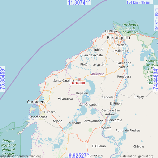
Luruaco GPS coordinates[2]
10° 37' 1.632" North, 75° 9' 5.256" West
| Map corner | latitude | longitude |
|---|---|---|
| Upper-left | 11.30741°, | -75.85459° |
| Center: | 10.61712°, | -75.15146° |
| Lower-right: | 9.92527°, | -74.44834° |
| Map W x H: | 153.7×153.7 km | = 95.5×95.5mi |
| max Lat: | 13.38166° ⇑3.1% North |
| Luruaco: | 10.61712° |
| min Lat: | ⇓96.9% South -4.21528° |
| min Long | Luruaco | max Long |
| -81.70636° | -75.15146° | -67.06996° |
| W 41.9%⇐ | ⇒58.1% E |
Elevation
Elevation of Luruaco is 28 m = 92 ft, and this is 1121.3 m = 3679 ft below average elevation for this country.
| Max E: |
3342 m = 10965 ft | 90.4% |
| Avg. | 1149.3 m = 3771 ft | |
| Luruaco | 28 m = 92 ft | |
Min E: |
1 m = 3 ft | 9.6% |
See also: Colombia elevation on elevation.city.
Geographical zone
Luruaco is located in North Torrid zone (between Equator and Tropic of Cancer). Distance of Equator is 1180.5 km =733.5 mi to South.| Distance of | km | miles | from Luruaco |
|---|---|---|---|
| North Pole | 8826.5 | 5484.5 | to North |
| Arctic Circle | 6220.7 | 3865.4 | to North |
| Tropic Cancer | 1425.4 | 885.7 | to North |
| Equator | 1180.5 | 733.5 | to South |


Nearby cities:
15 places around Luruaco: (largest is in red/bold)
• Baranoa
32.4 km =20.1 mi,  52°
52°
• Clemencia
19.8 km =12.3 mi,  253°
253°
• Juan de Acosta
26.9 km =16.7 mi,  28°
28°
• Manatí
28.4 km =17.6 mi,  132°
132°
• Piojó
15.4 km =9.6 mi,  18°
18°
• Repelón
13.9 km =8.6 mi,  167°
167°
• Sabanalarga
25.1 km =15.6 mi,  86°
86°
• San Cristóbal
26.4 km =16.4 mi,  159°
159°
• San Estanislao
24.3 km =15.1 mi,  179°
179°
• Santa Catalina
15 km =9.3 mi,  264°
264°
• Santa Rosa
30.6 km =19 mi,  231°
231°
• Soplaviento
24.9 km =15.5 mi, 177°
• Tubará
34.4 km =21.4 mi, 33°
• Usiacurí
23.7 km =14.7 mi, 53°
• Villanueva
23.4 km =14.5 mi,  214°
214°
Sources, notices
• [Note1] Compared only with cities in Colombia existing in our database
• [Src1] Map data: © OpenStreetMap contributors (CC-BY-SA)
• [Src2] Other city data from geonames.org with taken over terms of usage.
• [Src3] Geographical zone / Annual Mean Temperature by Robert A. Rohde @ Wikipedia
