Clemencia geodata
Clemencia (Bolívar) is a seat of a second-order administrative division; located in Colombia in America/Bogota (GMT-5) time zone. With population of 8,775 people, there are 347 cities with bigger population in this country. Compared to other cities in Colombia, 96.5% of cities are located further ↓South; 62.3% of cities are located further →East and 84.3% of cities have higher elevation than Clemencia. Note1


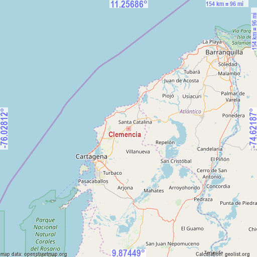
Clemencia GPS coordinates[2]
10° 33' 59.22" North, 75° 19' 29.964" West
| Map corner | latitude | longitude |
|---|---|---|
| Upper-left | 11.25686°, | -76.02812° |
| Center: | 10.56645°, | -75.32499° |
| Lower-right: | 9.87449°, | -74.62187° |
| Map W x H: | 153.7×153.7 km | = 95.5×95.5mi |
| max Lat: | 13.38166° ⇑3.5% North |
| Clemencia: | 10.56645° |
| min Lat: | ⇓96.5% South -4.21528° |
| min Long | Clemencia | max Long |
| -81.70636° | -75.32499° | -67.06996° |
| W 37.7%⇐ | ⇒62.3% E |
Elevation
Elevation of Clemencia is 67 m = 220 ft, and this is 1082.3 m = 3551 ft below average elevation for this country.
| Max E: |
3342 m = 10965 ft | 84.3% |
| Avg. | 1149.3 m = 3771 ft | |
| Clemencia | 67 m = 220 ft | |
Min E: |
1 m = 3 ft | 15.7% |
See also: Colombia elevation on elevation.city.
Geographical zone
Clemencia is located in North Torrid zone (between Equator and Tropic of Cancer). Distance of Equator is 1174.9 km =730 mi to South.| Distance of | km | miles | from Clemencia |
|---|---|---|---|
| North Pole | 8832.2 | 5488.1 | to North |
| Arctic Circle | 6226.3 | 3868.8 | to North |
| Tropic Cancer | 1431 | 889.2 | to North |
| Equator | 1174.9 | 730 | to South |


Nearby cities:
15 places around Clemencia: (largest is in red/bold)
• Arjona
34.8 km =21.6 mi,  183°
183°
• Cartagena
27.8 km =17.3 mi,  228°
228°
• Luruaco
19.8 km =12.3 mi,  73°
73°
• Mahates
39.9 km =24.8 mi,  158°
158°
• Manatí
42.2 km =26.2 mi,  108°
108°
• Piojó
31.2 km =19.4 mi,  49°
49°
• Repelón
23.3 km =14.5 mi, 109°
• San Cristóbal
34.2 km =21.3 mi,  123°
123°
• San Estanislao
26.7 km =16.6 mi,  134°
134°
• Santa Catalina
5.8 km =3.6 mi,  44°
44°
• Santa Rosa
14.4 km =8.9 mi,  199°
199°
• Soplaviento
27.9 km =17.3 mi, 133°
• Turbaco
28 km =17.4 mi, 199°
• Turbaná
35.2 km =21.9 mi, 201°
• Villanueva
14.8 km =9.2 mi, 157°
Sources, notices
• [Note1] Compared only with cities in Colombia existing in our database
• [Src1] Map data: © OpenStreetMap contributors (CC-BY-SA)
• [Src2] Other city data from geonames.org with taken over terms of usage.
• [Src3] Geographical zone / Annual Mean Temperature by Robert A. Rohde @ Wikipedia
