La Mesa geodata
La Mesa (Cundinamarca) is a populated place; located in Colombia in America/Bogota (GMT-5) time zone. With population of 26,699 people, there are 138 cities with bigger population in this country. Compared to other cities in Colombia, 55.9% of cities are located further ↑North; 67% of cities are located further ←West and 98.1% of cities have lower elevation than La Mesa. Note1


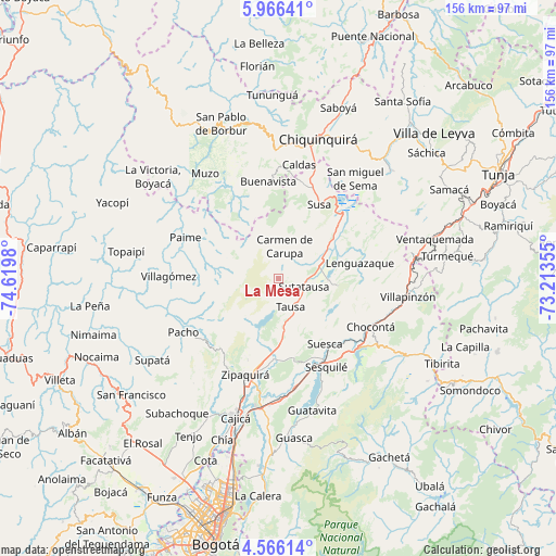
La Mesa GPS coordinates[2]
5° 16' 0.012" North, 73° 55' 0.012" West
| Map corner | latitude | longitude |
|---|---|---|
| Upper-left | 5.96641°, | -74.6198° |
| Center: | 5.26667°, | -73.91667° |
| Lower-right: | 4.56614°, | -73.21355° |
| Map W x H: | 155.7×155.7 km | = 96.7×96.7mi |
| max Lat: | 13.38166° ⇑55.9% North |
| La Mesa: | 5.26667° |
| min Lat: | ⇓44.1% South -4.21528° |
| min Long | La Mesa | max Long |
| -81.70636° | -73.91667° | -67.06996° |
| W 67%⇐ | ⇒33% E |
Elevation
Elevation of La Mesa is 2884 m = 9462 ft, and this is 1734.7 m = 5691 ft above average elevation for this country.
| Max E: |
3342 m = 10965 ft | 1.9% |
| La Mesa | 2884 m 9462 ft | |
| Avg. | 1149.3 m = 3771 ft | |
Min E: |
1 m = 3 ft | 98.1% |
See also: Colombia elevation on elevation.city.
Geographical zone
La Mesa is located in North Torrid zone (between Equator and Tropic of Cancer). Distance of Equator is 585.6 km =363.9 mi to South.| Distance of | km | miles | from La Mesa |
|---|---|---|---|
| North Pole | 9421.5 | 5854.2 | to North |
| Arctic Circle | 6815.6 | 4235 | to North |
| Tropic Cancer | 2020.3 | 1255.4 | to North |
| Equator | 585.6 | 363.9 | to South |


Nearby cities:
15 places around La Mesa: (largest is in red/bold)
• Carmen de Carupa
9.3 km =5.8 mi,  10°
10°
• Cogua
23.9 km =14.9 mi,  196°
196°
• Coper
27.3 km =17 mi,  328°
328°
• Cucunubá
16.8 km =10.4 mi,  96°
96°
• Fúquene
20.3 km =12.6 mi,  41°
41°
• Lenguazaque
23.2 km =14.4 mi,  78°
78°
• Nemocón
22.5 km =14 mi,  168°
168°
• San Cayetano
14.4 km =8.9 mi,  302°
302°
• San Cayetano
17.4 km =10.8 mi,  282°
282°
• Simijaca
27.2 km =16.9 mi,  15°
15°
• Suesca
22.4 km =13.9 mi,  144°
144°
• Susa
23.5 km =14.6 mi,  28°
28°
• Sutatausa
7.4 km =4.6 mi,  106°
106°
• Tausa
8 km =5 mi,  159°
159°
• Villa de San Diego de Ubaté
12.1 km =7.5 mi,  66°
66°
Sources, notices
• [Note1] Compared only with cities in Colombia existing in our database
• [Src1] Map data: © OpenStreetMap contributors (CC-BY-SA)
• [Src2] Other city data from geonames.org with taken over terms of usage.
• [Src3] Geographical zone / Annual Mean Temperature by Robert A. Rohde @ Wikipedia
