Planeta Rica geodata
Planeta Rica (Córdoba) is a populated place; located in Colombia in America/Bogota (GMT-5) time zone. With population of 37,297 people, there are 103 cities with bigger population in this country. Compared to other cities in Colombia, 83.2% of cities are located further ↓South; 68.5% of cities are located further →East and 82.5% of cities have higher elevation than Planeta Rica. Note1


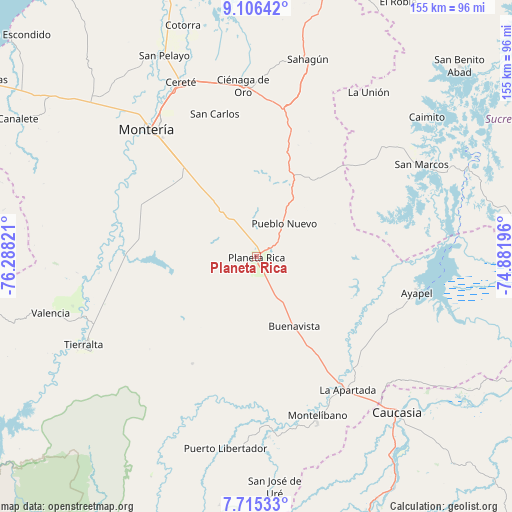
Planeta Rica GPS coordinates[2]
8° 24' 41.4" North, 75° 35' 6.288" West
| Map corner | latitude | longitude |
|---|---|---|
| Upper-left | 9.10642°, | -76.28821° |
| Center: | 8.4115°, | -75.58508° |
| Lower-right: | 7.71533°, | -74.88196° |
| Map W x H: | 154.7×154.7 km | = 96.1×96.1mi |
| max Lat: | 13.38166° ⇑16.8% North |
| Planeta Rica: | 8.4115° |
| min Lat: | ⇓83.2% South -4.21528° |
| min Long | Planeta Rica | max Long |
| -81.70636° | -75.58508° | -67.06996° |
| W 31.5%⇐ | ⇒68.5% E |
Elevation
Elevation of Planeta Rica is 88 m = 289 ft, and this is 1061.3 m = 3482 ft below average elevation for this country.
| Max E: |
3342 m = 10965 ft | 82.5% |
| Avg. | 1149.3 m = 3771 ft | |
| Planeta Rica | 88 m = 289 ft | |
Min E: |
1 m = 3 ft | 17.5% |
See also: Colombia elevation on elevation.city.
Geographical zone
Planeta Rica is located in North Torrid zone (between Equator and Tropic of Cancer). Distance of Equator is 935.3 km =581.2 mi to South.| Distance of | km | miles | from Planeta Rica |
|---|---|---|---|
| North Pole | 9071.8 | 5637 | to North |
| Arctic Circle | 6465.9 | 4017.7 | to North |
| Tropic Cancer | 1670.6 | 1038.1 | to North |
| Equator | 935.3 | 581.2 | to South |


Nearby cities:
15 places around Planeta Rica: (largest is in red/bold)
• Ayapel
50.2 km =31.2 mi,  102°
102°
• Buenavista
23.9 km =14.9 mi,  151°
151°
• Cereté
57.3 km =35.6 mi,  336°
336°
• Ciénaga de Oro
51.6 km =32.1 mi,  355°
355°
• La Apartada
48.7 km =30.3 mi, 145°
• La Unión
59.2 km =36.8 mi,  34°
34°
• Montelíbano
51.4 km =31.9 mi,  159°
159°
• Montería
49.6 km =30.8 mi,  318°
318°
• Moñitos
54.2 km =33.7 mi,  250°
250°
• Pueblo Nuevo
13.1 km =8.1 mi,  40°
40°
• Puerto Libertador
58.8 km =36.5 mi,  189°
189°
• San Carlos
39.5 km =24.5 mi, 339°
• San Carlos
44.5 km =27.7 mi, 343°
• San Marcos
57.3 km =35.6 mi,  61°
61°
• Tierralta
58.5 km =36.4 mi,  243°
243°
Sources, notices
• [Note1] Compared only with cities in Colombia existing in our database
• [Src1] Map data: © OpenStreetMap contributors (CC-BY-SA)
• [Src2] Other city data from geonames.org with taken over terms of usage.
• [Src3] Geographical zone / Annual Mean Temperature by Robert A. Rohde @ Wikipedia
