Moñitos geodata
Moñitos (Córdoba) is a populated place; located in Colombia in America/Bogota (GMT-5) time zone. With population of 5,385 people, there are 482 cities with bigger population in this country. Compared to other cities in Colombia, 82.1% of cities are located further ↓South; 81% of cities are located further →East and 87.3% of cities have higher elevation than Moñitos. Note1


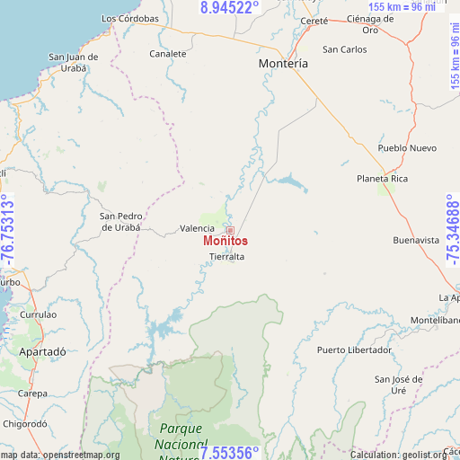
Moñitos GPS coordinates[2]
8° 15' 0" North, 76° 3' 0" West
| Map corner | latitude | longitude |
|---|---|---|
| Upper-left | 8.94522°, | -76.75313° |
| Center: | 8.25°, | -76.05° |
| Lower-right: | 7.55356°, | -75.34688° |
| Map W x H: | 154.7×154.7 km | = 96.1×96.1mi |
| max Lat: | 13.38166° ⇑17.9% North |
| Moñitos: | 8.25° |
| min Lat: | ⇓82.1% South -4.21528° |
| min Long | Moñitos | max Long |
| -81.70636° | -76.05° | -67.06996° |
| W 19%⇐ | ⇒81% E |
Elevation
Elevation of Moñitos is 44 m = 144 ft, and this is 1105.3 m = 3626 ft below average elevation for this country.
| Max E: |
3342 m = 10965 ft | 87.3% |
| Avg. | 1149.3 m = 3771 ft | |
| Moñitos | 44 m = 144 ft | |
Min E: |
1 m = 3 ft | 12.7% |
See also: Colombia elevation on elevation.city.
Geographical zone
Moñitos is located in North Torrid zone (between Equator and Tropic of Cancer). Distance of Equator is 917.3 km =570 mi to South.| Distance of | km | miles | from Moñitos |
|---|---|---|---|
| North Pole | 9089.7 | 5648.1 | to North |
| Arctic Circle | 6483.9 | 4028.9 | to North |
| Tropic Cancer | 1688.6 | 1049.2 | to North |
| Equator | 917.3 | 570 | to South |


Nearby cities:
15 places around Moñitos: (largest is in red/bold)
• Apartadó
75.4 km =46.9 mi,  237°
237°
• Buenavista
62.6 km =38.9 mi,  92°
92°
• Canalete
50.3 km =31.3 mi,  340°
340°
• Canalete
63.1 km =39.2 mi, 340°
• Cereté
76.1 km =47.3 mi,  22°
22°
• Montelíbano
75.6 km =47 mi,  113°
113°
• Montería
58.4 km =36.3 mi, 18°
• Planeta Rica
54.2 km =33.7 mi,  70°
70°
• Pueblo Nuevo
65.8 km =40.9 mi,  64°
64°
• Puerto Libertador
57.9 km =36 mi,  133°
133°
• San Carlos
66.2 km =41.1 mi,  33°
33°
• San Carlos
71.9 km =44.7 mi, 32°
• San Pedro de Urabá
36 km =22.4 mi,  274°
274°
• Tierralta
8.6 km =5.3 mi,  186°
186°
• Valencia
11 km =6.8 mi, 274°
Sources, notices
• [Note1] Compared only with cities in Colombia existing in our database
• [Src1] Map data: © OpenStreetMap contributors (CC-BY-SA)
• [Src2] Other city data from geonames.org with taken over terms of usage.
• [Src3] Geographical zone / Annual Mean Temperature by Robert A. Rohde @ Wikipedia
